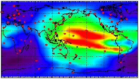
Global Ionospheric Maps
 Data from over 100+ continuously operating GPS receivers in a global
network are being used to produce global maps of the ionosphere's total
electron content (TEC). These Global Ionosphere Maps (GIM) provide instantaneous
"snapshots" of the global TEC distribution, by interpolating, in both
space and time, the 6-8 simultaneous TEC measurements obtained from each GPS
receiver every 30 seconds. The maps can be produced unattended in a real-time
mode, with an update rate of 5-15 minutes.
Data from over 100+ continuously operating GPS receivers in a global
network are being used to produce global maps of the ionosphere's total
electron content (TEC). These Global Ionosphere Maps (GIM) provide instantaneous
"snapshots" of the global TEC distribution, by interpolating, in both
space and time, the 6-8 simultaneous TEC measurements obtained from each GPS
receiver every 30 seconds. The maps can be produced unattended in a real-time
mode, with an update rate of 5-15 minutes.
Monitoring Global Ionospheric Weather
 GIMs
represent a new tool for monitoring global patterns of ionospheric weather, a
key component of the space weather, which is driven by changes in solar
ultra-violet radiation, the interplanetary particle stream known as the solar
wind, and the underlying composition, wind patterns and electrodynamics of the
thermosphere (the upper atmosphere at altitudes between 100 and 1000 km). GIMs
are being used for global ionospheric delay calibrations, for scientific
investigations of the upper atmosphere, and will be an important data source for
the National Space Weather Program.
GIMs
represent a new tool for monitoring global patterns of ionospheric weather, a
key component of the space weather, which is driven by changes in solar
ultra-violet radiation, the interplanetary particle stream known as the solar
wind, and the underlying composition, wind patterns and electrodynamics of the
thermosphere (the upper atmosphere at altitudes between 100 and 1000 km). GIMs
are being used for global ionospheric delay calibrations, for scientific
investigations of the upper atmosphere, and will be an important data source for
the National Space Weather Program.