The World Magnetic Model is a product of the United States National Geospatial-Intelligence Agency (NGA). The U.S. National Geophysical Data Center (NGDC) and the British Geological Survey (BGS) produced the WMM with funding provided by NGA in the USA and by the Defence Geographic Imagery and Intelligence Agency (DGIA) in the UK. The World Magnetic Model is the standard model of the US Department of Defense, the UK Ministry of Defence, the North Atlantic Treaty Organization (NATO), and the World Hydrographic Office (WHO) navigation and attitude/heading referencing systems. It is also used widely in civilian navigation systems. The model, associated software, and documentation are distributed by NGDC on behalf of NGA. The model is produced at 5-year intervals, with the current model expiring on December 31, 2009.
|
|
|
|
Last Modified on: Wednesday, 15-Dec-2004 17:46:01 MST NOAA > NESDIS > NGDC |
|
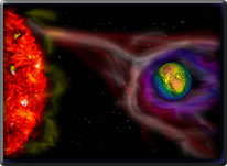
The World Magnetic Model - BackgroundThe Earth's magnetic field, as measured by a magnetic sensor on or above the Earth's surface, is actually a composite of several magnetic fields generated by a variety of sources. These fields are superimposed on each other and through inductive processes interact with each other. The most important of these geomagnetic fields are: |
|
|
 |
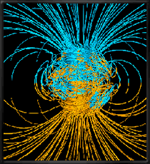 |
The observed magnetic field is a sum of contributions of the main field (varying in both time and space), the crustal field (varies spatially, but considered constant in time for the time-scales of the WMM), and the disturbance fields (varying in space and rapidly in time). Earth's main magnetic field dominates, accounting for over 95% of the field strength at the Earth’s surface. Secular variation is the slow change in time of the main magnetic field. The WMM represents only the main geomagnetic field. Simulation of Earth's core by Gary Glatzmaier et. al. Los Alamos National Labs |
|
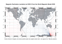
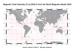
To create an accurate main field model, you need data with good global coverage and as low a noise level as possible. The Danish Ørsted and German CHAMP satellite data sets satisfy these requirements. Both satellites provide high quality vector and scalar data at all latitudes and longitudes, but not during all time periods needed for modeling. These satellite data were augmented with ground observatory hourly mean data, which were available almost continuously over the period of interest, although with poorer spatial coverage. The observatory data provide valuable constraints on the time variations of the geomagnetic field. Used together, satellite and observatory data provide an exceptional quality data set for modeling the behaviour of the main magnetic field in space and time. The WMM consists of a degree and order 12 spherical-harmonic main (i.e., core-generated) field model comprised of 168 spherical-harmonic Gauss coefficients and degree and order 12 spherical-harmonic Secular-Variation (SV) (core-generated, slow temporal variation) field model (determined to degree and order 8). WMM2005 supersedes WMM2000 and should replace this model in navigation systems. Also included with the model is computer software (available in FORTRAN or C) for computing the magnetic field components X, Y, Z, F, D, I, and H in geodetic coordinates. The spherical-harmonic expansions used to compute the magnetic field components are described in the NOAA Technical Report: The US/UK World Magnetic Model for 2005-2010 (zip ~8.3 Mb or pdf format ~8.7 Mb). The World Magnetic Model is a product of the United States National Geospatial-Intelligence Agency (NGA). The U.S. National Geophysical Data Center (NGDC) and the British Geological Survey (BGS) produced the WMM with funding provided by NGA in the USA and by the Defence Geographic Imagery and Intelligence Agency (DGIA) in the UK. The World Magnetic Model is the standard model of the US Department of Defense , the UK Ministry of Defence, the North Atlantic Treaty Organization (NATO), and the World Hydrographic Office (WHO) navigation and attitude/heading referencing systems. It is also used widely in civilian navigation systems. |
|