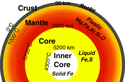
Earth's Interior
The Earth, the Sun, and the rest of the solar system, was formed 4.54 billion years ago by accretion from a rotating disk of dust and gas. The immense amount of heat energy released from gravitational energy and from the decay of radioactive elements melted the entire planet, and it is still cooling off today. Denser materials like iron (Fe) sank into the core of the Earth, while lighter silicates (Si), other oxygen (O) compounds, and water rose near the surface.
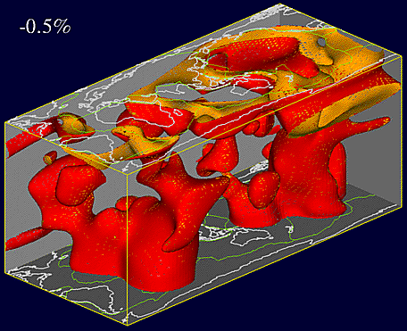
(J. Louie)
The earth is divided into four main layers: the inner core, outer core,
mantle, and crust. The core is composed mostly of iron (Fe) and is so
hot that the outer core is molten, with about 10% sulphur (S). The inner
core is under such extreme pressure that it remains solid. Most of the
Earth's mass is in the mantle, which is composed of iron (Fe), magnesium (Mg),
aluminum (Al), silicon (Si), and oxygen (O) silicate compounds. At over
1000 degrees C, the mantle is solid but can deform slowly in a plastic
manner. The crust is much thinner than any of the other layers, and is composed
of the least dense calcium (Ca) and sodium (Na) aluminum-silicate minerals.
Being relatively cold, the crust is rocky and brittle, so it can fracture
in earthquakes.
Knowing that the Earth has a radius of about 6370 km, you have a right triangle where the cosine of half of 105 degrees equals the radius of the core divided by the radius of the earth.
The fact that the Earth has a magnetic field is an independent piece of evidence for a molten, liquid core. A compass magnet aligns with the magnetic field anywhere on the Earth. The earth cannot be a large permanent magnet, since magnetic minerals lose their magnetism when they are hotter than about 500 degrees C. Almost all of the earth is hotter, and the only other way to make a magnetic field is with a circulating electric current. Circulation and convection of electrically conductive molten iron in the Earth's outer core produces the magnetic field. To make the magnetic field, the convection must be relatively rapid (much faster than it is in the plastic mantle), so the core must be fluid. Much of the energy to drive this convection comes from growth of the solid inner core, with the release of energy as the iron changes from solid to liquid.
Because the Earth's magnetic field arises in the unstable patterns of fluid flow in the core, it changes direction at irregular intervals. In recent geologic history it may have switched direction about every 200,000 years. Any kind of geologic deposit (e.g.: lava flows, layered muds) put down over time will thus have different layers magnetized in opposing directions, recording the magnetic field direction as it was when the layer solidified. Geophysicists can measure the changes in direction to make a magnetostratigraphy for the deposit.
At oceanic spreading centers new ocean floor is being created
constantly and slowly moved away from the rift. The farther the rock is from the
rift, the older it is, and it will also show the magnetic reversals like
a tape recording.

(original
image from the Harvard Univ.
Seismology Lab; used by
permission)
In this view from the southwest the red blobs are warmer plumes of less dense
material, rising principally into the ocean-ridge spreading centers. A huge
plume seems to be feeding spreading at the East Pacific Rise directly from the
core. Most of the heat being released from the earth's interior emerges at the
fast-spreading East Pacific Rise.

(J. Louie)
The part of the mantle near the crust, about 50-100 km down, is especially soft
and plastic, and is called the asthenosphere. The mantle and crust above
are cool enough to be tough and elastic, and are known as the lithosphere.
A heavy load on the crust, like an ice cap, large glacial lake, or
mountain range, can bend the lithosphere down into the asthenosphere, which can
flow out of the way. The load will sink until it is supported by buoyancy.
If an ice cap melts or lake dries up due to climatic changes, or a mountain
range erodes away, the lithosphere will buoyantly rise back up over thousands of
years. This is the process of isostatic rebound.
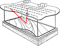
Seismic reflection sections can show blocks of the crust in great detail.
Individual layers can be studied for their potential to hold oil, gas, or water;
to conduct contaminants from a dump site; or to describe their geologic origin
and history.
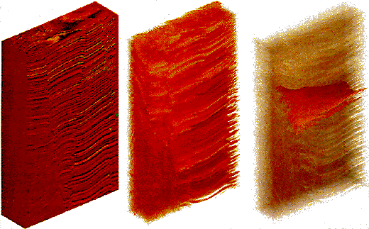
(from Soc. of Explor. Geophysicists,
The Leading Edge, v. 11, no. 11, p. 13; used by
permission)
This study of one layer maps out an ancient network of sandy stream
channels, much like the modern channels of the Laramie River, right. Such
buried channels can yield oil or gas easily if seismic reflection work can
pinpoint their locations.
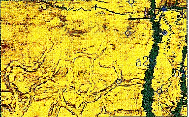

(from Soc. of Explor. Geophysicists,
The Leading Edge, v. 12, no. 6, p. 683; v. 11, no. 8, p. 13; used
by
permission)
Development geophysicists can build detailed models of complex structures
having many different formations deformed by all types of faults and folds. With
these details they can plan the extraction of oil, gas, coal, or other minerals.
They can also predict how ground water may flow through an area, and find
the most efficient strategies to clean up contamination.
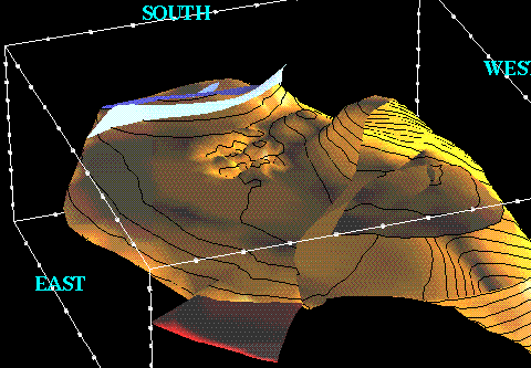
(from Soc. of Explor. Geophysicists,
The Leading Edge, v. 10, no. 8, p. 15; used by
permission)
Geophysicists can also make maps of other physical properties that rocks show over an area. Gravitational pull, magnetic field strength, electrical conductivity, radioactivity, and spectral reflectance are all properties that may be used to detect particular rock formations of economic or geologic interest, even if they are buried below the surface.

(from Soc. of Explor. Geophysicists,
The Leading Edge, v. 9, no. 9, p. 41; used by
permission)
The maps above are derived from maps of magnetic field strength in a part of
Nevada. Computerized artificial illumination from the right direction reveals a
subtle lineament in the image. A buried, slightly magnetized dike
could contain gold ores.
(from Soc. of Explor. Geophysicists,
The Leading Edge, v. 9, no. 9, p. 39; used by
permission)
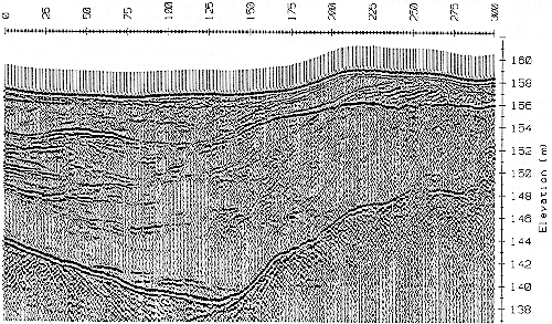
The image above is the output of a ground-probing radar, which is very
good at locating buried pipes, cavities, fractures, and metallic objects. Here
it reveals the detailed structure of a soil layer only 20 m thick, showing
channels likely to collect contaminated ground water.
This page originally published at: http://www.seismo.unr.edu/ftp/pub/louie/class/100/interior.html