The Earth's Interior
Just as a child may shake an unopened present in an attempt to discover the
contents of a gift, so man must listen to the ring and vibration of our
Earth in an attempt to
discover its content. This is accomplished through seismology, which has become
the principle method used in studying Earth's interior. Seismos is a Greek word
meaning shock; akin to earthquake, shake, or violently moved. Seismology on
Earth deals with the study of vibrations that are produced by earthquakes, the
impact of meteorites, or
artificial means such as an explosion. On these occasions, a seismograph is used
to measure and record the actual movements and vibrations within the Earth and
of the ground.
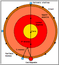
Scientists categorize seismic movements into four types of diagnostic waves
that travel at speeds ranging from 3 to 15 kilometers (1.9 to 9.4 miles) per
second. Two of the waves travel around the surface of the Earth in rolling
swells. The other two, Primary (P) or compression waves and Secondary (S) or
shear waves, penetrate the interior of the Earth. Primary waves compress and
dilate the matter they travel through (either rock or liquid) similar to sound
waves. They also have the ability to move twice as fast as S waves. Secondary
waves propagate through rock but are not able to travel through liquid. Both P
and S waves refract or reflect at points where layers of differing physical
properties meet. They also reduce speed when moving through hotter material.
These changes in direction and velocity are the means of locating
discontinuities.
 |
|
Types of seismic waves
(Adapted from, Beatty, 1990.)
|
 |
Divisions in the Earth's Interior
(Adapted from, Beatty, 1990.) |
Seismic discontinuities aid in distinguishing divisions of the Earth into
inner core, outer core, D", lower mantle, transition region, upper mantle, and
crust (oceanic and continental). Lateral discontinuities also have been
distinguished and mapped through seismic tomography but shall not be discussed
here.
- Inner core: 1.7% of the Earth's mass; depth of 5,150-6,370 kilometers
(3,219 - 3,981 miles)
The inner core is solid and unattached to the mantle, suspended in the molten
outer core. It is believed to have solidified as a result of pressure-freezing
which occurs to most liquids when temperature decreases or pressure increases.
- Outer core: 30.8% of Earth's mass; depth of 2,890-5,150 kilometers
(1,806 - 3,219 miles)
The outer core is a hot, electrically conducting liquid within which
convective motion
occurs. This conductive layer combines with Earth's rotation to create a
dynamo effect that maintains a system of electrical currents known as the
Earth's magnetic field. It is also responsible for the subtle jerking of
Earth's rotation. This layer is not as dense as pure molten iron, which
indicates the presence of lighter elements. Scientists suspect that about 10%
of the layer is composed of sulfur and/or oxygen because these elements are
abundant in the cosmos and dissolve readily in molten iron.
- D": 3% of Earth's mass; depth of 2,700-2,890 kilometers (1,688 - 1,806
miles)
This layer is 200 to 300 kilometers (125 to 188 miles) thick and represents
about 4% of the mantle-crust mass. Although it is often identified as part of
the lower mantle, seismic discontinuities suggest the D" layer might differ
chemically from the lower mantle lying above it. Scientists theorize that the
material either dissolved in the core, or was able to sink through the mantle
but not into the core because of its density.
- Lower mantle: 49.2% of Earth's mass; depth of 650-2,890 kilometers (406
-1,806 miles)
The lower mantle contains 72.9% of the mantle-crust mass and is probably
composed mainly of silicon, magnesium, and oxygen. It probably also contains
some iron, calcium, and aluminum. Scientists make these deductions by assuming
the Earth has a similar abundance and proportion of cosmic elements as found
in the Sun and primitive meteorites.
- Transition region: 7.5% of Earth's mass; depth of 400-650 kilometers
(250-406 miles)
The transition region or mesosphere (for middle mantle), sometimes called the
fertile layer, contains 11.1% of the mantle-crust mass and is the source of
basaltic
magmas. It also
contains calcium, aluminum, and garnet, which is a complex aluminum-bearing
silicate mineral. This layer is dense when cold because of the garnet. It is
buoyant when hot because these minerals melt easily to form basalt which can
then rise through the upper layers as magma.
- Upper mantle: 10.3% of Earth's mass; depth of 10-400 kilometers (6 -
250 miles)
The upper mantle contains 15.3% of the mantle-crust mass. Fragments have been
excavated for our observation by eroded mountain belts and volcanic eruptions.
Olivine (Mg,Fe)2SiO4 and pyroxene (Mg,Fe)SiO3 have been the primary minerals
found in this way. These and other minerals are refractory and crystalline at
high temperatures; therefore, most settle out of rising magma, either forming
new crustal material or never leaving the mantle. Part of the upper mantle
called the asthenosphere might be partially molten.
- Oceanic crust: 0.099% of Earth's mass; depth of 0-10 kilometers (0 - 6
miles)
The oceanic crust contains 0.147% of the mantle-crust mass. The majority of
the Earth's crust was made through volcanic activity. The oceanic ridge
system, a 40,000-kilometer (25,000 mile) network of volcanoes, generates new
oceanic crust at the rate of 17 km3 per year, covering the ocean
floor with basalt. Hawaii and Iceland are two examples of the accumulation of
basalt piles.
- Continental crust: 0.374% of Earth's mass; depth of 0-50 kilometers (0
- 31 miles).
The continental crust contains 0.554% of the mantle-crust mass. This is the
outer part of the Earth composed essentially of crystalline rocks. These are
low-density buoyant minerals dominated mostly by quartz (SiO2) and feldspars
(metal-poor silicates). The crust (both oceanic and continental) is the
surface of the Earth; as such, it is the coldest part of our planet. Because
cold rocks deform slowly, we refer to this rigid outer shell as the
lithosphere (the rocky or strong layer).
The Lithosphere & Plate Tectonics
The rigid, outermost layer of the Earth comprising the crust and upper mantle is
called the lithosphere. New oceanic lithosphere forms through volcanism in the
form of fissures at mid-ocean ridges which are cracks that encircle the globe.
Heat escapes the interior as this new lithosphere emerges from below. It
gradually cools, contracts and moves away from the ridge, traveling across the
seafloor to subduction zones in a process called seafloor spreading. In time,
older lithosphere will thicken and eventually become more dense than the mantle
below, causing it to descend (subduct) back into the Earth at a steep angle,
cooling the interior. Subduction is the main method of cooling the mantle below
100 kilometers (62.5 miles). If the lithosphere is young and thus hotter at a
subduction zone, it will be forced back into the interior at a lesser angle.
The continental lithosphere is about 150 kilometers (93 miles) thick with a
low-density crust and upper-mantle that are permanently buoyant. Continents
drift laterally along the convecting system of the mantle away from hot mantle
zones toward cooler ones, a process known as continental drift. Most of the
continents are now sitting on or moving toward cooler parts of the mantle, with
the exception of Africa. Africa was once the core of Pangaea, a supercontinent
that eventually broke into todays continents. Several hundred million years
prior to the formation of Pangaea, the southern continents - Africa, South
America, Australia, Antarctica, and India - were assembled together in what is
called Gondwana.
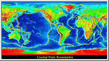
Crustal Plate Boundaries
(Courtesy NGDC)
Plate tectonics involves the formation, lateral movement, interaction, and
destruction of the lithospheric plates. Much of Earth's internal heat is
relieved through this process and many of Earth's large structural and
topographic features are consequently formed. Continental
rift valleys
and vast plateaus of
basalt are created at plate break up when
magma ascends from
the mantle to the ocean floor, forming new crust and separating midocean ridges.
Plates collide and are destroyed as they descend at subduction zones to produce
deep ocean trenches, strings of volcanoes, extensive transform
faults, broad linear
rises, and folded mountain belts. Earth's lithosphere presently is divided into
eight large plates with about two dozen smaller ones that are drifting above the
mantle at the rate of 5 to 10 centimeters (2 to 4 inches) per year. The eight
large plates are the African, Antarctic, Eurasian, Indian-Australian, Nazca,
North American, Pacific, and South American plates. A few of the smaller plates
are the Anatolian, Arabian, Caribbean, Cocos, Philippine, and Somali plates.
References
Beatty, J. K. and A. Chaikin, eds. The New Solar System.
Massachusetts: Sky Publishing, 3rd Edition, 1990.
Press, Frank and Raymond Siever. Earth. New York: W. H. Freeman and
Company, 1986.
Seeds, Michael A. Horizons. Belmont, California: Wadsworth, 1995.
This page originally published at:
http://www.solarviews.com/eng/earthint.htm