Playa lakes and the Ogallala Aquifer
- What's the Connection?
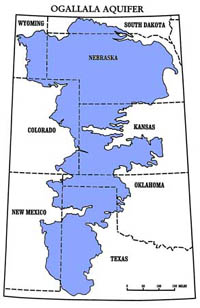
The Ogallala Aquifer underlies approximately 174,000 square miles of the Great Plains region, primarily in Texas, New Mexico, Oklahoma, Kansas, Colorado and Nebraska. The Ogallala has long been a major source of water for municipalities, industries, and most notably agricultural development since the turn of the century. In 1990, the aquifer was measured to contain about 3.270 billion acre-feet of water. Pumping for irrigation is the primary use of the aquifer. In 1949, the Ogallala irrigated four million acres - by 1997 it irrigated 14 million acres. Consequently, the aquifer's water supply has declined steadily since the 1940s and recent measurements show a 1.35-ft. drop per year from 1992 to 1997. Although current dry land farming techniques have resulted in reduced pumping, the amount of groundwater being withdrawn still greatly surpasses the aquifer's nature rate of recharge.
The Ogallala Aquifer underlies approximately 174,000 square miles of the Great Plains region, primarily in Texas, New Mexico, Oklahoma, Kansas, Colorado and Nebraska. The Ogallala has long been a major source of water for municipalities, industries, and most notably agricultural development since the turn of the century. In 1990, the aquifer was measured to contain about 3.270 billion acre-feet of water. Pumping for irrigation is the primary use of the aquifer. In 1949, the Ogallala irrigated four million acres - by 1997 it irrigated 14 million acres. Consequently, the aquifer's water supply has declined steadily since the 1940s and recent measurements show a 1.35-ft. drop per year from 1992 to 1997. Although current dry land farming techniques have resulted in reduced pumping, the amount of groundwater being withdrawn still greatly surpasses the aquifer's nature rate of recharge.

Scientists have gathered substantial evidence pointing to playa wetlands as the primary, and some say the exclusive, source of recharge for the Ogallala Aquifer. Many studies indicate that recharge into the Ogallala under playas exceeds three inches per year, while recharge in inter-playa uplands occurs at 0.004 inches to 0.03 inches per year. Although these results have been known for quite some time, the ramifications have not been realized by the general public or even conservation professionals.

Click on images for larger view.
Since about 99 percent of playas are located on private land, this information is crucial for landowners and natural resource managers who hope to conserve water and maintain agricultural economies of the region. The PLJV is seeking landowners, land managers and other partners to help conserve playa lakes in the western Great Plains.