NASA finds Greenland snow melting hit record high in high places

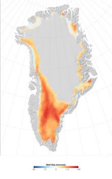
Microwave data from the Special Sensor Microwave Imaging
radiometer was used to create this image of the 2007
Greenland melting anomaly which reflects the difference
between the number of melting days occurring in 2007 and the
average number of melting days during the period 1988 –
2006. Credit: NASA/Earth Observatory
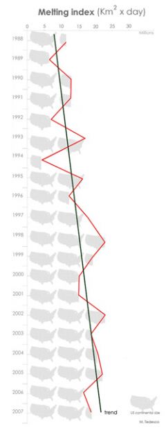
 Marco Tedesco summarizes the trend of the melting index in Greenland between 1988 and 2007 by showing a plot of how many surface size of the U.S. match the melting index observed each year of his study. Credit: NASA/Marco Tedesco and Luisa Valle |
"When snow melts at those high altitudes and then refreezes, it can absorb up to four times more energy than fresh, unthawed snow," said Tedesco. "This can affect Earth's energy budget by changing how much radiation from the sun is absorbed by the Earth versus that reflected back into the atmosphere. Refrozen snow can also alter the snow density, thickness and snow-water content." Tedesco's findings were published Sept. 25 in the American Geophysical Union's Eos newspaper.
Researchers determine the melting index by multiplying how long melting took place by the area where the increased melting took place. According to Tedesco, melting in April and May of this year in high-altitude areas was very low, but in June melting jumped unexpectedly and led to the record melting index for the year.
"This record melting index in those areas came as a bit of a surprise, showing us, once again, the extreme variability and complexity of these processes," said Tedesco. His expertise in documenting melting trends produced other recent studies on increased snow melting over Greenland and the Antarctic.
The data collected by the Special Sensor Microwave Imagers on the Defense Meteorological Satellite Program satellites provided Tedesco with insight into how much of an electromagnetic signal was naturally emitted by snow and ice in areas beneath the satellite overpass. The microwave instruments can detect melting above and below the snow surface. The data were processed at the National Snow and Ice Data Center in Boulder, Colo., in just 24 hours after the satellite overpass, enabling Tedesco to quickly spot changes that could signal a melting trend or new record.
"Increases in the overall melting trend over Greenland have an impact that stretches beyond its icy shores," said Tedesco. "Aside from contributing to direct sea level rise, melting especially along the coast can speed up glaciers since the meltwater acts like a lubricant between the frozen surface and the bedrock deep below. The faster glaciers flow, the more water enters the ocean and potentially impacts sea level rise."
Tedesco, along with U.S. and European colleagues, plans to combine satellite data with related climate model results. He plans to visit Greenland in 2008 to compare his findings from space-borne data with those obtained by ground-based sensors, all with an eye to gathering further clues of what is happening on Greenland.
Source: Goddard Space Flight Center