Taiwan and Coastal China Shut Down Ahead of Monster Typhoon
TAIPEI, Taiwan, August 6, 2009 (ENS) - Strengthening as it blows across the western Pacific Ocean, Typhoon Morakot is now on a collision course with Taiwan and China's eastern provinces. Already tagged as the worst typhoon this year, the storm has doubled its size over the past two days, U.S. satellite imagery shows.
"Our satellite scan swath width is 1,700 kilometers (1,056 miles) and Morakot looks to be almost that much in diameter in the infrared imagery on August 5," said Ed Olsen, of NASA's Jet Propulsion Laboratory in Pasadena, California.
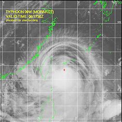 |
Typhoon Morakot looms over the island of Taiwan and coastal China, outlined in green. (Image courtesy JTWC) |
"On August 4, Morakot was only about half of our swath width, near 850 kilometers (528 miles) in diameter," said Olsen, who provides images for the Atmospheric Infrared Sounder instrument on NASA's Aqua satellite.
Now located approximately 165 nautical miles southeast of Taipei, Morakot is moving westward at 14 knots and has maintained an intensity of 80 knots over the past six hours, according to the U.S. Naval Maritime Forecast Center/Joint Typhoon Warning Center based in Pearl Harbor, Hawaii.
The Taiwan Central Weather Bureau reports that Typhoon Morakot is carrying winds of just over 150 kilometers per hour (93 mph), makes it a Category 1 hurricane.
Weather forecasters predict Morakot will hit Taiwan as a Category 2 storm, lashing the entire island with intense rain and damaging winds on Friday and Saturday.
Taiwan Premier Liu Chao-shiuan today inspected the Central Emergency Operation Center and ordered all personnel to remain on high alert for the next 24 hours, when the typhoon is forecast to affect all regions of Taiwan.
Taiwan Coast Guard officers patrolled the Hualien coast, warning beachgoers to move up to higher ground.
Government offices and schools across the island will be closed Friday, airlines have canceled their domestic flight schedules, and the Taiwan Stock Exchange announced that the market would be closed Friday.
 |
Storm clouds from Typhoon Morakot loom over Taipei. (Photo by Pheng Yao) |
The typhoon will end recent water scarcity and threatened water rationing in Taiwan, but forecasters say the storm will create other problems - mudslides in the hills and floods in low-lying areas.
Off the coast of mainland China, some 900 Chinese and foreign tourists have been evacuated from from the Nanji Islands National Nature Reserve, which is also a UNESCO Biosphere Reserve.
Chinese authorities are bracing for the storm, expected to land in the eastern provinces of Zhejiang or Fujian between Saturday noon and Sunday morning.
State media reports that in Fujian province nearly 8.4 million short messages have been sent to mobile phone users by 5:30 pm, warning them to prepare for the typhoon.
Provincial flood control and drought relief headquarters ordered fishing boats and construction vessels to seek shelter, and tonight more than 1,200 vessels returned to harbors.
Authorities have evacuated 5,240 people in Fujian as sea waves up to six meters (20 feet) battered fish farms.
Weather forecasters said the typhoon could push coastal sea surge as high as nine meters (30 feet) at the peak of the storm.
Morakot is the eighth tropical storm to strike the region so far this year. The most recent storm, Goni, caused deadly landslides in the Philippines earlier this week before hitting the Chinese province of Guangdong on Wednesday morning, destroying 732 houses.
"The two storms could influence each other," Wang Zhenming, vice head of the Zhejiang provincial meteorological station told the Xinhua official news agency. "As a result, the route of Morakot is not fully predictable."
Wang warned that Morakot is likely to continue growing in strength and become a super typhoon.
Copyright Environment News Service (ENS) 2009. All rights reserved.
To subscribe or visit go to: http://www.ens-newswire.com