Sea Levels Rose as Much as Two Feet This Summer in U.S. East
Sea levels rose as much as 2 feet (60 centimeters) higher than
predicted this summer along the U.S. East Coast, surprising scientists
who forecast such periodic fluctuations.
The immediate cause of the unexpected rise has now been solved, U.S.
officials say in a new report (hint: it wasn't global warming). But the
underlying reason remains a mystery.
A new report from NOAA has identified the two major factors behind the high sea levels—a weakened Gulf Stream and steady winds from the northeastern Atlantic.
The Gulf Stream is a northward-flowing superhighway of ocean water off the U.S. East Coast. Running at full steam, the powerful current pulls water into its "orbit" and away from the East Coast.
But this summer, for reasons unknown, "the Gulf Stream slowed down," Edwing said, sending water toward the coasts—and sea levels shooting upward.
Adding to the sustained surge, autumn winds from the northeastern Atlantic arrived a few months early, pushing even more water coastward.

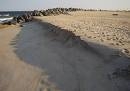
Beaches "Eaten Up"
The higher waters caused inconveniences for some anglers and boaters and rearranged a bit of shoreline.
"A couple of sand beaches we'd normally fish from were eaten up. And the volume of water was higher than it normally would be," said Paulie Apostolides, owner of Paulie's Tackle in Montauk (map) on New York State's Long Island.
Even before the new report, released by NOAA on September 2, Apostolides said many local fishers had already attributed the sea level rise to the "ferocious" winds from the northeast.
But the underlying puzzle remains.
"Why did the Gulf Stream slow down? Why did the fall wind pattern appear earlier?" NOAA's Edwing said. "We don't have those answers."
© 1996-2009 National Geographic Society. All rights reserved. To subscribe or visit go to: http://news.nationalgeographic.com