Dangerous Heat and Severe Weather. Solar Flare and Tropical Storm Colin


Courtesy NASA (SOHO)
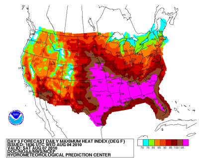
Excessive heat warnings and advisories are in place across much of lower and mid Mississippi river valleys and into the Tennessee valley. Expect heat indices to range from 110 to 115 degrees. It’s not out of the question to see isolated areas approaching 120°heat index. It will also be hot and humid across the southeast and Mid-Atlantic States today prompting heat advisories to be posted throughout these regions.
There were 244 reports of severe weather yesterday, with the bulk of
them in the mid-Atlantic and the Ohio and Mississippi Valleys. There
were 4 fatalities reported on Wednesday. Two people died when a barn
collapsed in Hartford, Ohio with 15 people inside. We have a slight risk
for severe thunderstorms in western Kentucky and Tennessee and from the
New England region back down into the Mid-Atlantic States.There is a
moderate risk for severe storms today in Colorado. SEE SLIDE
BELOW
A small solar flare erupted on the Sun on August 1st 2010. A coronal
mass ejection (CME) moved towards the earth at 2.5 million miles per
hour. It arrived on Earth on Tuesday August 3rd 2010 causing a
geomagnetic storm. The forecast calls for the strongest activity today
as the Earth is hit with another CME.
Geophysical Activity Forecast: Geomagnetic field activity is expected to be at unsettled to active levels until midday on day 1 (05 August). Activity is forecast to increase to active to minor storm levels with a chance for major storm levels beginning midday on 05 August due to the expected arrival of a CME associated with a large filament disappearance on 01 August.
The remnant low of Tropical Storm Colin is showing signs of getting
better organized however there is no evidence from surface observations
of a low level circulation. With that said tropical force winds are
likely to occur or are occurring north of the Virgin Islands. This area
of low pressure could become Tropical Storm Colin again later today. Air
Force reconnaissance is schedule to fly into this area and we will get a
better look at what is happening. The National Hurricane Center (NHC)
gives this area a 50% of developing into a tropical cyclone within 48
hours.
At this time the remnant low of Colin is moving towards the northwest at
20 mph. Computer models take Colin on a classic re-curve path, between
the U.S. east coast and Bermuda and then out to the north Atlantic. This
area is experiencing very high wind shear at this time; however once it
gets out of this hostile environment, conditions will become more
favorable for development. Only one computer models predicts Colin will
become a hurricane, but there is a consensus of other models that Colin
will regain Tropical Storm status. SEE SLIDE BELOW
We are also monitoring Invest 92L located in the Southwest Caribbean
Sea. The NHC gives this area a 10% chance of development within the next
2 days. However this system could become a tropical cyclone before it
reaches the Central American coast in the next day or two. The rest of
the tropics are quiet for the time being.
Colorado State University kept their season forecast numbers the same calling for 18 named storms 10 hurricanes and 5 major hurricanes. We will have more on these numbers later this week.
Heat Index for Today
Look at Tropical Threats
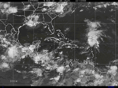
Courtesy of Cooperative Institute for Meteorological Satellite Studies
*************************
Hurricane season runs from June 1 to November 30 with about 80% of tropical storms and hurricanes developing during August, September, and October. In a typical year, 11 named storms develop and 6 of these become hurricanes. On average, some portion the District is affected by at least one named storm every other year, a hurricane every 3 years, and a major hurricane every 6-7 years.
Tropical Cyclone Categories:
-Tropical Depression 20 knots/23 mph
-Tropical Storm 34 knots/39 mph
-Category 1 Hurricane 64 knots/74 mph
-Category 2 Hurricane 84 knots/96 mph
-Category 3 Hurricane 97 knots/111 mph
-Category 4 Hurricane 114 knots/131 mph
-Category 5 Hurricane 136 knots/156 mph
Please leave a comment or ask any question about the subjects that have been covered. Steve will be monitoring this page and will answer your questions in a timely manner. You can also follow Steve on Twitter ipr365@twitter.com or email Steve at
swoliver@cfl.rr.comResource Links:
Copyright © 2009 Clarity Digital Group LLC d/b/a Examiner.com. All Rights reserved. To subscribe or visit go to: http://www.examiner.com