
Elephant seal with CTD tag. Photo credit: Chris Oosthuizen
Australian climate and ocean scientists are studying some of the planet's most remote areas using a multi-million dollar array of high-tech underwater equipment that provides data vital for the monitoring of almost one-third of the world's oceans. The kit of technology includes sensor floats and autonomous underwater vehicles, which combine with sensor tagged animals, moored scientific stations and satellite remote sensing to form the Integrated Marine Observing System (IMOS).


All data collected by IMOS is available free at the institution's webportal, the IMOS Ocean Portal. The integration of this data and its online presentation at the IMOS Ocean Portal represents big step forward in climate science.

"This is a unique approach to monitoring the linkage between the physical properties of oceans, such as temperature and salinity, and how they influence the marine ecosystem," Oceanographer and leader of the IMOS ocean and climate node Dr Susan Wijffels said.
IMOS brings together ocean and climate scientists from research institutions across the globe, including the University of Tasmania, the Commonwealth Scientific and Industrial Research Organisation (CSIRO), Australian Antarctic Division, Bureau of Meteorology, Australian Institute of Marine Science, Sydney Institute of Marine Science, and University of Western Australia. There is also continued collaboration with northern hemisphere partners, including the United States, France, the United Kingdom, and Korea.
Dr Wijffels, believes IMOS is helping to foster cooperation between scientific disciplines that have not traditionally worked together.
"What is happening in the open ocean is vitally important to all Australians and their understanding of local and regional climate," IMOS Director, Tim Moltmann said. "It drives our climate and weather extremes, is the workplace for offshore industries and maritime defence activities and contains a diversity of marine life that currently is barely described. We need to observe this part of the earth system to understand how it's changing, and what the impacts might be on current and future generations."
The technology
Agro Floats
Argo floats measure temperature and salinity between the ocean's surface and a depth of 2000 m (6500 ft) every 10 days. This data is streamed in real-time to the IMOS Ocean Portal and quality-controlled data is released after six months. The Argo floats provide essential data for ocean and climate research and prediction. Argo Australia is operated by CSIRO Marine and Atmospheric Research based in Hobart, Tasmania with operational support from the Bureau of Meteorology and financial support from IMOS.
Argo floats change their buoyancy by driving oil from inside the float to an external bladder using an electric motor and battery pack. This alters the floats volume and density relative to the surrounding seawater letting in move vertically through the water column. The Argo floats also drift with the ocean currents providing information on the direction and speed of the ocean's flow, or the Lagrangian velocity as it is known.
Deep Ocean Gliders
The IMOS project has a fleet of eight unmanned ocean glider vehicles. These are given GPS waypoints and with the aid of an onboard computer, they glide between these points using vertical movement by regulating buoyancy and horizontal movement using a combination of wings, which give the gliders forwards motion, and a shifting weight, which allows the vehicles to roll and therefore turn. The glider travels at speeds of around 30-40 cm/s (~0.5 knot) and can be controlled at any time by scientists via satellite.
Data captured by the gliders includes temperature, salinity, dissolved oxygen, turbidity, chlorophyll and depth. Average water velocities can also be interpreted by seeing how far from its expected course the glider has drifted. Researchers have an option to add extra sensors to the gliders to tailor what observations are being made.
The IMOS project has two class of gliders the Slocum gliders and Seagliders. Slocum are currently equipped with a Seabird-CTD, WETLabs BBFL2SLO 3 parameter optical sensor (measuring Chlorophyll-a, CDOM & 660nm Backscatter) and an Aanderaa Oxygen optode. The Seagliders are fitted with a Seabird-CTD, WETLabs BBFL2VMT 3 parameter optical sensor (measuring Chlorophyll-a, CDOM & 660nm Backscatter) and a Seabird Oxygen sensor.
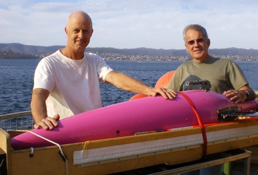
Autonomous Underwater Vehicle (AUV)
The IMOS AUV Facility is lead by the University of Sydney's Australian Centre for Field Robotics. The Facility a Autonomous Underwater Vehicle (AUV) called Sirius used for undertaking high resolution stereo survey work. It is a modified version of a mid-size robotic submarine called Seabed built at the Woods Hole Oceanographic Institution. It is equipped with a range of oceanographic instruments, including a high resolution stereo camera pair and strobes, a multibeam sonar, depth and conductivity/temperature sensors, Doppler Velocity Log (DVL) including a compass with integrated roll and pitch sensors, Ultra Short Baseline Acoustic Positioning System (USBL) and forward looking obstacle avoidance sonar. Sirius has a maximum depth rating of 700m (2300ft), has a propulsion system consisting of three 150W brushless DC thrusters powered by a 1.6 kWh Li-ion battery pack.
Animal Tagging

The Australian Animal Tagging and Monitoring System (AATAMS) uses acoustic technology, CTD satellite trackers and bio loggers to monitor coastal and oceanic movements of marine animals from the Australian mainland to the sub-Antarctic islands and as far south as the Antarctic continent. AATAMS is set up to collect data over a long period of time to enable researchers to assess the effects of climate change, ocean acidification and other physical changes on animals within the marine environment.
Currently a large range of fish, sharks and mammals including seals are used. Information collected includes behavioural and physical data such as the depth, temperature, salinity and movement of individual marine animals. Real-time data is available free of charge at the IMOS Ocean Portal.
Other technology
A number of other technologies are used in the IMOS program including the so-called ships of opportunity, various moored observation stations and satellite remote sensing.
IMOS is supported by the Australian Government, through the National Collaborative Infrastructure Strategy and the Super Science Initiative. It is led by the University of Tasmania on behalf of the Australian marine and climate science community. CSIRO is the lead institution for the IMOS ocean and climate node.
Copyright © gizmag 2003 - 2010 To subscribe or visit go to: http://www.gizmag.com