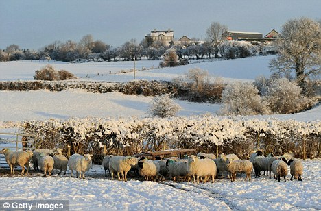
Feeling the chill: Sheep
huddle together in a snow covered field on Christmas
Day morning in Letterkenny, Ireland
The scale that measures the pressure difference
between Iceland and the Azores goes from around plus 5
to minus 5. It is most of the time flitting between plus
and minus 2. But sometimes it gets stuck for a few
weeks. And when it gets stuck at an extreme – anywhere
around plus or minus 4 or 5 – that’s when we get weird
weather.
The NAO record in the past century shows this
clearly. There have been only occasional winter quarters
when the index has averaged below minus 4. They were the
1963 big freeze, another pipe-bursting winter in 1969
and early 2010, when we again got blanketed in snow.
Since mid-November this year, the NAO has been way
down again, approaching minus 4.
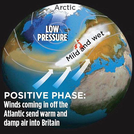
The NAO has been in a generally positive phase for
the past 25 years. As a result, winters have usually
been mild since the late Eighties, encouraging one
climatologist to predict an end to winter snow in
Britain.
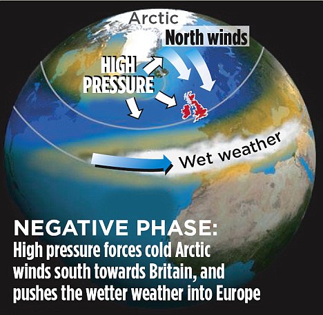
But in the middle of summer 2009, it slipped back
into a negative phase that has persisted month after
month since, bringing us last winter’s snow and now our
current record-breaking December freeze.
This year, the index has been in strongly negative
territory since mid-November, reaching lows of
approaching minus 4 as the snow set in during late
November and again on December 18 – the Saturday that
brought chaos to southern England.
The NAO influences British weather most strongly in
winter. But it can have a summer effect too. During a
positive phase, those winds coming in off the Atlantic
keep us cool (and damp) in summer.
But when the NAO goes negative, we get hot, dry
summers with droughts. The NAO has gone below minus 5 in
the summer only once in the past century. It gave us the
notorious drought of 1976.
Can we forecast it? Not very well, even short-term.
Though when it gets ‘stuck’ at an extreme point, there
is usually a reasonable chance it will stay stuck for a
bit. As it has over the past month.
The Met Office is being cautious about what happens
next. Its best forecast is a likely ‘return to near
normal temperatures’ next month. But some analysts say
the big chill could continue for weeks. When it ends,
there could be a flurry of storms as the wet westerly
winds reassert themselves.
The Government has asked its chief scientific adviser
John Beddington to report on whether this year is the
start of a long-term trend to colder winters. I can
predict caution will ensure he doesn’t come up an
absolute answer.
But often the long-term swings of the NAO bring
clusters of warm or cold winters. So the odds must be
shortening.
What about global warming? Doesn’t this all make
those theories about warming look a bit stupid? Well,
no. The NAO is only cooling a small area round northern
Europe. Elsewhere in the world, 2010 has seen
near-record warm temperatures.
In November, northern Europe was a most unusual 4C
colder than normal. But according to Nasa, last month
was the warmest-ever November worldwide. Right now,
there are record temperatures west of Greenland and into
Canada, where they are wondering when winter will start.
We seem to have got the weather they usually have
around Hudson Bay in Canada – and they have got ours.
Blame that on the NAO.
Many climate scientists want to link up the recent
wild swings of the NAO with global warming. But they
can’t work out what the link is – or if there is a link.
Last year Mojib Latif at the Leibniz Institute at the
University of Kiel in Germany argued that the long
positive phase of NAO from the Eighties to 2009 had
helped to warm the world in the past 30 years. It was
responsible for at least part of global warming.
But others argue that the boot is on the other foot –
that it was global warming that pushed the NAO into its
long positive phase. Another bunch of researchers, led
by James Overland of the U.S. government’s National
Oceanic and Atmospheric Administration, has been
suggesting in recent weeks that global warming is
kicking the NAO into a kind of super-negative state and
causing our bad winters.
Overland points out that global warming is causing
massive summer melting of Arctic ice and he says this is
playing havoc with the old weather patterns.
If that is right, then we have the weird prospect of
global warming unfreezing the Arctic and kicking
northern Europe into a run of colder winters without
end.
But others are dubious about this theory, including
the legendary Nasa climate guru Jim Hansen. Frankly,
they don’t know.
So what can we say? The big long-term driver of
climate change still looks like the greenhouse effect of
gases such as carbon dioxide we put into the air every
time we burn fossil fuels.
But global warming is only about global averages.
What it means for real weather, place by place, day by
day and season by season, is still impossible to
predict.
And, in our corner of the world, the NAO is likely to
carry on determining a lot of the ups and downs on our
way to a warmer world.
Right now, I am going out to buy a shovel.
Read more:
http://www.dailymail.co.uk/sciencetech/article-1341618/Why-cold-Simple--North-Atlantic-Oscillation--got-bit-stuck.html#ixzz19QU1lct2