Haiti At Risk for More Damaging Earthquakes This Year
RESTON, Virginia, February 24, 2010 (ENS) - Earthquake aftershocks are still being felt in the ruined city of Port-au-Prince - a 4.7 magnitude quake 20 miles away shook the city early Tuesday morning and another of the same magnitude was felt on Monday. Even though further damage and deaths were not reported, the aftershocks cause frightened residents to flee their homes lest cracked buildings fall, burying them in rubble as so many others were buried on January 12.
Haiti will remain at risk for additional damaging earthquakes for at least the next year, according to an updated scientific analysis by the U.S. Geological Survey issued Tuesday.
The magnitude 7.0 earthquake of January 12 near Port-au-Prince, has generated a sharp increase in concerns about the potential for future earthquakes in Haiti and the surrounding region.
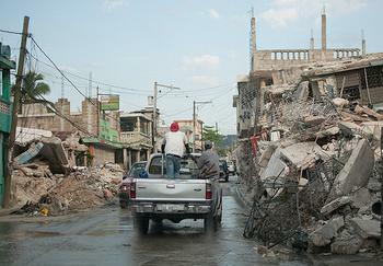 |
Ruined buildings on a Port-au-Prince street. February 22, 2010. (Photo by Dan Lundmark) |
Because these concerns extend to understanding the causes of the earthquake hazard and learning what can be done to ensure seismic safety in the future, USGS Director Marcia McNutt has asked the team of USGS earthquake scientists to provide a continuing evaluation of the earthquakes facing Haiti now and in the future.
The death toll in the disastrous January 12 quake could reach 300,000 once all the bodies are recovered, Haitian President Rene Preval told a meeting of Latin American and Caribbean leaders in Mexico on Sunday.
"More than 200,000 bodies were collected on the streets without counting those that are still under the rubble," Preval said. "We could arrive at 300,000 deaths." Haitian government officials estimate 700,000 people are living outdoors in tents and that one in three of Haiti's 10 million residents were affected by the quake.
As the world rushes millions of dollars in recovery aid to Haiti, the USGS scientists predict that the aftershock activity will continue for many months, although they say the frequency of these events should diminish with time.
USGS scientists estimate the probability of an aftershock with a magnitude of 7.0 or greater within the next year is three percent; within the next three months, two percent, and within the next 30 days just one percent.
An aftershock with a magnitude of 6.0 or greater is predicted with 25 percent likelihood within the next year, 15 percent within the next three months, and five percent within the next 30 days.
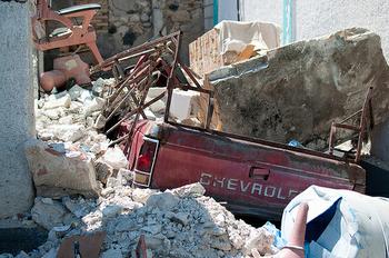 |
Rubble in Port-au-Prince, February 21, 2010 (Photo by Dan Lundmark) |
Within the next year there is a 95 percent chance of an aftershock of magnitude 5.0 or greater. Within the next three months, that probability drops to 80 percent, and within the next 30 days the probability of a magnitude 5.0 aftershock drops to 55 percent.
"Any aftershock above magnitude 5.0 will be widely felt and has the potential to cause additional damage, particularly to vulnerable, already damaged structures," the USGS warns.
"Everyone in the Port-au-Prince area must maintain awareness with regard to their personal earthquake safety. Individuals should always have in mind what action to take if the ground starts to shake. Open spaces are generally safe. If indoors, drop to the floor, take cover under a sturdy desk or table, and wait for the shaking to stop," the USGS advises. "Do not go outdoors until the shaking stops."
Only qualified engineers can determine if a damaged building is safe for reoccupation. Until engineering assistance arrives, the USGS advises, "If it does not look safe, it probably is not safe. Entry into or reoccupation of obviously damaged structures should be avoided."
The geologic fault that caused the Port-au-Prince earthquake is part of a seismically active zone between the North American and Caribbean tectonic plates. The January 12 earthquake relieved some stress on the fault segment that ruptured during the event, but the USGS scientists say the extent of rupture along the fault is unclear at this time.
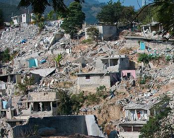 |
Ruined Port-au-Prince neighborhood, February 21, 2010 (Photo by Dan Lundmark) |
Fault slip models, preliminary radar surface deformation measurements, and examination of satellite and airborne imagery for surface rupture suggest that the segment of the Enriquillo fault to the east of the January 12 epicenter and directly adjacent to Port-au-Prince did not slip appreciably in the earthquake.
This means that the Enriquillo fault zone near Port-au-Prince still stores sufficient strain to be released as a large, damaging earthquake during the lifetime of structures built during the current reconstruction effort.
"We have estimated the probabilities of a future large earthquake on the Enriquillo fault," the USGS scientists said. "Our estimates indicate a probability range of five percent to 15 percent, less than one chance in six, for an earthquake of magnitude 7 on the Enriquillo fault near Port-au-Prince during the next 50 years."
For comparison, the probability of a magnitude 7.0 or greater earthquake within the next 50 years on the Hayward-Rodgers Creek fault in the eastern portion of California's San Francisco Bay region is also about 15 percent.
Given these estimates of earthquake hazard, buildings in Port-au-Prince and environs will continue to be at risk from strong earthquake shaking. These risks can be minimized through the use of earthquake-resistant design and construction practices that apply the results of a comprehensive earthquake hazard assessment. It has been shown that the benefits of losses avoided through earthquake mitigation practices outweigh the costs, the USGS advises.
This entire region is seismically active due to the relative motion between tectonic plates and is prone to damaging earthquakes. It is a small-scale "ring of fire" similar to that encircling the Pacific Ocean.
Over the past three centuries, earthquakes as strong or stronger than the recent one have struck Haiti at least four times, including those in 1751 and 1770 that destroyed Port-au-Prince.
Historical earthquakes greater than magnitude 7.0 have occurred in Puerto Rico, Jamaica, Dominican Republic, Martinique, and Guadeloupe.
Along the northern coast of Venezuela, the juncture of the Caribbean and South American plates has caused damaging earthquakes in the vicinity of Trinidad and Tobago. The USGS advises that earthquake safety policy, including building codes throughout the region, should be based on thorough seismic hazard assessments.
Copyright Environment News Service (ENS) 2010. All rights reserved.
To subscribe or visit go to: http://www.ens-newswire.com