| New Wind Potential Estimates for the US Based on AWS Truewind's windNavigator System |
 Albany-based
AWS Truewind, LLC has announced the release of new wind
potential estimates for the lower 48 states based on
windNavigator, the firm's proprietary, high-resolution wind
resource dataset. The estimates were produced in collaboration
with the National Renewable Energy Laboratory (NREL) under the
auspices of the US Department of Energy (DOE). They mark the
first comprehensive state-level assessment of the onshore wind
resource potential since 1993. Albany-based
AWS Truewind, LLC has announced the release of new wind
potential estimates for the lower 48 states based on
windNavigator, the firm's proprietary, high-resolution wind
resource dataset. The estimates were produced in collaboration
with the National Renewable Energy Laboratory (NREL) under the
auspices of the US Department of Energy (DOE). They mark the
first comprehensive state-level assessment of the onshore wind
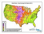
resource potential since 1993.“We are delighted to have been able to support the US Department of Energy and NREL in the important task of improving understanding of the wind potential of the United States,” said Bruce Bailey, President and CEO of AWS Truewind. “Our history with DOE and NREL spans over a decade dating back to a time when wind resource maps were not as widely accepted as they are today. We are proud to be an integral part of the industry’s progress and are confident that our commitment to innovation will continue to play an important role in the industry’s success,” added Bailey. windNavigator, a seamless, high-resolution dataset developed by AWS Truewind, contains detailed wind resource data for points spaced 200 m (650 ft) apart throughout the US. It was created through a sophisticated weather modeling process and fine-tuned using observations from over 1600 wind monitoring stations around the country. For this assessment, AWS Truewind converted the wind resource data to annual average plant output for a generic commercial wind turbine model. This resulted in maps of the estimated annual gross capacity factor (without losses) at heights of 80 m (260 ft) and 100 m (330 ft) above ground. Using AWS Truewind’s capacity factor maps, NREL estimated the potential wind plant rated capacity in megawatts for each state in various capacity factor ranges. Lands that are unlikely to be developed due to environmental protections, incompatible land use, or other factors that may impact development such as steep slope were excluded from the final estimates. According to Michael Brower, AWS Truewind’s chief technical officer, the new estimates are directly relevant to the needs of today’s wind industry. “The estimates indicate the power output that would be produced by today’s commercially available wind turbines with hub heights of 80 m to 100 m,” said Brower. “We believe they will provide critical support to state and federal policy makers working to stimulate wind energy development in the United States,” adds Brower. The increase in the potential estimates for the 80m and 100m heights compared to the 50m height of previous estimates is significant. According to Dennis Elliott, NREL’s principal scientist in wind resource assessment, “areas with gross capacity factor of 30% and greater are generally considered to have suitable wind resource for wind development with today’s advanced wind turbine technology. The new estimates for 80m height and capacity factor of 30% and greater indicate about 10,500 GW developable potential in the contiguous United States, compared to previous estimates of 7,000 to 8,000 GW for 50m height and power Class 3 and greater.” “Although much of this potential comes from the windy central regions of the United States, many eastern and western states have substantial wind potential, and 35 states have 1,000 MW or greater potential,” added Elliott. At a 100m height, the wind potential increases to about 12,000 GW and 38 states have 1,000 MW or greater potential.” The new state-by-state estimates are available on the AWS Truewind and NREL websites (www.awstruewind.com/windpotential.cfm and www.windpoweringamerica.gov/filter_detail.asp?itemid=2542). A report describing how AWS Truewind developed the gross capacity factor data, the primary reasons why some of the new estimates differ from previous estimates, and an in-depth explanation of the differences for certain states, is also available on AWS Truewind’s website (www.awstruewind.com/windpotential.cfm). AWS Truewind’s high-resolution wind resource dataset, which includes mean annual speed grids, capacity factor, DEM, land cover, speed distribution, wind rose, monthly and diurnal, is commercially available from the windNavigator website: http://navigator.awstruewind.com. AWS Truewind, LLC |
© 2010 North American Clean Energy To subscribe or visit go to: http://nacleanenergy.com