NOAA: May Global Temperature is Warmest on Record
Spring and January-May also post record breaking temps
June 15, 2010
The combined global land and ocean surface temperature was the warmest on record for May, March-May (Northern Hemisphere spring-Southern Hemisphere autumn), and the period January-May according to NOAA. Worldwide average land surface temperature for May and March-May was the warmest on record while the global ocean surface temperatures for both May and March-May were second warmest on record, behind 1998.
The monthly analysis from NOAA’s National Climatic Data Center, which is based on records going back to 1880, is part of the suite of climate services NOAA provides government, business and community leaders so they can make informed decisions.
Global Highlights – May 2010
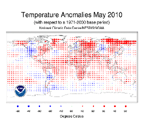
- The combined global land and ocean surface temperature for May was the warmest on record, at 1.24°F (0.69°C) above the 20th century average of 58.6°F (14.8°C).
- The global land surface temperature for May was 1.87°F (1.04°C) above the 20th century average of 52.0°F (11.1°C) — the warmest on record.
- The May worldwide ocean temperature was the second warmest on record, behind 1998. The temperature anomaly was 0.99°F (0.55°C) above the 20th century average of 61.3°F (16.3°C).
- Warm temperatures were present over most of the globe’s land areas. The warmest temperature anomalies occurred in eastern North America, eastern Brazil, Eastern Europe, southern Asia, eastern Russia, and equatorial Africa. The Chinese province of Yunnan had its warmest May since 1951. Numerous locations in Ontario, Canada had their warmest May on record.
- Anomalously cool conditions were present across western North America, northern Argentina, interior Asia, and Western Europe. Germany had its coolest May since 1991 and its 12th coolest May on record.
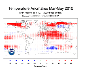
Global Highlights – March-May 2010
- The combined global land and ocean average surface temperature for the March-May season was 58.0°F (14.4°C), which is the warmest such period on record and 1.31°F (0.73°C) above the 20th century average of 56.7°F (13.7°C).
- The worldwide land surface temperature for March-May was 2.20°F (1.22°C) above the 20th century average of 46.4 °F (8.1°C) — the warmest on record.
- The worldwide ocean surface temperature was 0.99°F (0.55°C) above the 20th century average of 61.0°F (16.1°C) and the second warmest March-May on record, behind 1998.
- Very warm temperatures were present across eastern and northern North America, northern Africa, Eastern Europe, southern Asia, and parts of Australia. Tasmania tied its warmest March-May period on record. The Northeastern U.S. also had its warmest March-May period on record. Conversely, cool temperatures enveloped the western U.S. and eastern Asia.
- Western Europe was particularly dry for its spring season. For the United Kingdom, it was the driest spring since 1984, and the twelfth driest since the UK record began in 1910.
Other Highlights
- Arctic sea ice covered an average of 5.06 million square miles (13.1 million square kilometers) during May. This is 3.7 percent below the 1979-2000 average extent and the ninth-smallest May footprint since records began in 1979. During May 2010, Arctic sea ice melted 50 percent faster than the average May melting rate, according to the National Snow & Ice Data Center.
- Antarctic sea ice extent in May was 7.3 percent above the 1979-2000 average, resulting in the fourth largest May extent on record.
- Northern Hemisphere snow cover extent during May 2010 was a record low at 4.3 million square kilometers below the long-term average. North America and Eurasia both had record-low snow extents for the month. Northern Hemisphere March-May snow cover extent was fourth smallest on record, while the North American (including Greenland) snow cover extent for spring (March-May) 2010 was the smallest on record.
Scientists, researchers, and leaders in government and industry use NOAA’s monthly reports to help track trends and other changes in the world's climate. This climate service has a wide range of practical uses, from helping farmers know what and when to plant, to guiding resource managers with critical decisions about water, energy and other vital assets.
Additional Information
May 2010 Global State of the Climate – Supplemental Figures & Information
NOAA understands and predicts changes in the Earth’s environment, from the depths of the oceans to surface of the sun, and conserves and manages our coastal and marine resources.