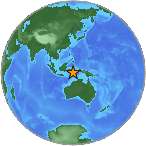
6.2 Mw - SULAWESI, INDONESIA
| Magnitude | 6.2 Mw |
| Date-Time |
|
| Location | 4.593S 122.807E |
| Depth | 9 km |
| Distances |
|
| Location Uncertainty | Horizontal: 13.1 km; Vertical 4.8 km |
| Parameters | Nph = 139; Dmin = 341.8 km; Rmss = 1.58 seconds; Gp = 50° M-type = Mw; Version = 7 |
| Event ID | US c0002y0p |
For updates, maps, and technical information, see:
Event Page
or
USGS Earthquake Hazards Program
National Earthquake Information Center
U.S. Geological Survey
http://neic.usgs.gov/