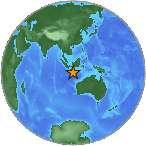
6.7 Mw - SOUTH OF JAVA, INDONESIA
| Magnitude | 6.7 Mw |
| Date-Time |
|
| Location | 9.786S 107.748E |
| Depth | 24 km |
| Distances |
|
| Location Uncertainty | Horizontal: 12.0 km; Vertical 7.0 km |
| Parameters | Nph = 168; Dmin = 242.7 km; Rmss = 1.18 seconds; Gp = 39° M-type = Mw; Version = 7 |
| Event ID | US c0002i9q |
For updates, maps, and technical information, see:
Event Page
or
USGS Earthquake Hazards Program
National Earthquake Information Center
U.S. Geological Survey
http://neic.usgs.gov/