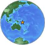
6.9 Mw - SOLOMON ISLANDS
| Magnitude | 6.9 Mw |
| Date-Time |
|
| Location | 10.349S 161.232E |
| Depth | 81 km |
| Distances |
|
| Location Uncertainty | Horizontal: 14.4 km; Vertical 7.9 km |
| Parameters | Nph = 393; Dmin = 173.7 km; Rmss = 0.86 seconds; Gp = 21° M-type = Mw; Version = 7 |
| Event ID | US c0002xcx |
For updates, maps, and technical information, see:
Event Page
or
USGS Earthquake Hazards Program
National Earthquake Information Center
U.S. Geological Survey
http://neic.usgs.gov/