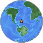
6.6 M - SOUTH SANDWICH ISLANDS REGION
| Magnitude | 6.6 M |
| Date-Time |
|
| Location | 56.406S 27.028W |
| Depth | 86 km |
| Distances |
|
| Location Uncertainty | Horizontal: 16.0 km; Vertical 0.0 km |
| Parameters | Nph = 149; Dmin = 645.7 km; Rmss = 1.14 seconds; Gp = 28° M-type = M; Version = 8 |
| Event ID | US b0001q4l |
For updates, maps, and technical information, see:
Event Page
or
USGS Earthquake Hazards Program
National Earthquake Information Center
U.S. Geological Survey
http://neic.usgs.gov/