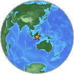
6.2 M - BALI SEA
| Magnitude | 6.2 M |
| Date-Time |
|
| Location | 6.895S 116.786E |
| Depth | 510 km |
| Distances |
|
| Location Uncertainty | Horizontal: 14.6 km; Vertical 1.0 km |
| Parameters | Nph = 114; Dmin = 338.4 km; Rmss = 0.92 seconds; Gp = 32° M-type = M; Version = 5 |
| Event ID | US c0001x0l |
For updates, maps, and technical information, see:
Event Page
or
USGS Earthquake Hazards Program
National Earthquake Information Center
U.S. Geological Survey
http://neic.usgs.gov/