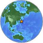
6.3 M - OFF EAST COAST OF HONSHU, JAPAN
| Magnitude | 6.3 M |
| Date-Time |
|
| Location | 38.492N 143.191E |
| Depth | 2 km |
| Distances |
|
| Location Uncertainty | Horizontal: 12.3 km; Vertical 1.7 km |
| Parameters | Nph = 372; Dmin = 391.8 km; Rmss = 0.85 seconds; Gp = 39° M-type = M; Version = 7 |
| Event ID | US b0001rey |
For updates, maps, and technical information, see:
Event Page
or
USGS Earthquake Hazards Program
National Earthquake Information Center
U.S. Geological Survey
http://neic.usgs.gov/