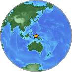
6.6 Mw - NEAR N COAST OF PAPUA, INDONESIA
| Magnitude | 6.6 Mw |
| Date-Time |
|
| Location | 1.609S 134.232E |
| Depth | 29 km |
| Distances |
|
| Location Uncertainty | Horizontal: 13.8 km; Vertical 4.9 km |
| Parameters | Nph = 206; Dmin = 263.8 km; Rmss = 1.39 seconds; Gp = 18° M-type = Mw; Version = A |
| Event ID | US c00098nl |
For updates, maps, and technical information, see:
Event Page
or
USGS Earthquake Hazards Program
National Earthquake Information Center
U.S. Geological Survey
http://neic.usgs.gov/