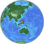
6.8 Mw - NEGROS- CEBU REG, PHILIPPINES
| Magnitude | 6.8 Mw |
| Date-Time |
|
| Location | 9.964N 123.245E |
| Depth | 46 km |
| Distances |
|
| Location Uncertainty | Horizontal: 13.5 km; Vertical 11.5 km |
| Parameters | Nph = 75; Dmin = 744.7 km; Rmss = 1.03 seconds; Gp = 46° M-type = Mw; Version = 8 |
| Event ID | US b0007wgq |
For updates, maps, and technical information, see:
Event Page
or
USGS Earthquake Hazards Program
National Earthquake Information Center
U.S. Geological Survey
http://neic.usgs.gov/