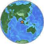
6.6 Mw - SIMEULUE, INDONESIA
| Magnitude | 6.6 Mw |
| Date-Time |
|
| Location | 2.654N 96.191E |
| Depth | 45 km |
| Distances |
|
| Location Uncertainty | Horizontal: 15.0 km; Vertical 10.9 km |
| Parameters | Nph = 77; Dmin = 214.8 km; Rmss = 1.04 seconds; Gp = 86° M-type = Mw; Version = 8 |
| Event ID | US b000bfha |
For updates, maps, and technical information, see:
Event Page
or
USGS Earthquake Hazards Program
National Earthquake Information Center
U.S. Geological Survey
http://neic.usgs.gov/