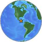
6.2 Mwb - NEAR COAST OF GUATEMALA
| Magnitude | 6.2 Mwb |
| Date-Time |
|
| Location | 14.206N 92.125W |
| Depth | 29 km |
| Distances |
|
| Location Uncertainty | Horizontal: 11.5 km; Vertical 6.6 km |
| Parameters | Nph = 535; Dmin = 229.4 km; Rmss = 1.04 seconds; Gp = 82° M-type = Mwb; Version = 9 |
| Event ID | us c000dr09 |
For updates, maps, and technical information, see:
Event Page
or
USGS Earthquake Hazards Program
National Earthquake Information Center
U.S. Geological Survey
http://earthquake.usgs.gov/regional/neic/