The Changing Coast Due to Hurricane Sandy
From: Andy Soos, ENN
Published November 16, 2012 10:43 AM
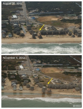
Hurricane Sandy was a monster. It changed lives and changed the actual land shapes along the coasts affected. The USGS has released a series of aerial photographs showing before-and-after images of Hurricane Sandy's impacts on the Atlantic Coast. Among the latest photo pairs to be published are images showing the extent of coastal change in North Carolina, Virginia, Maryland, and Delaware. The photos, part of a USGS assessment of coastal change from as far south as the Outer Banks of North Carolina to as far north as Massachusetts, show that the storm caused dramatic changes to portions of shoreline extending hundreds of miles. Pre- and post-storm images of the New Jersey and New York shoreline in particular tell a story of a coastal landscape that was considerably altered by the historic storm. Meanwhile, images from hundreds of miles south of the storm’s landfall demonstrate that the storm’s breadth caused significant coastal change as far south as the Carolinas.
"Sandy taught us yet again that not all Cat-1 hurricanes are created
equal: the superstorm's enormous fetch over the Atlantic produced storm
surge and wave erosion of historic proportions," said USGS Director
Marcia McNutt. "We have seized this opportunity to gather unique data on
a major coastline-altering event."
As major storms approach, the USGS conducts pre-storm and post-storm
flights to gather aerial images along the length of the coastline
expected to experience impacts from the storm’s landfall. Identifying
sites of such impacts helps scientists understand which areas are likely
to undergo the most severe impacts from future storms, and improves
future coastal impact forecasting.
Photo pairs from North Carolina to Massachusetts are now available
online.
"This storm’s impact on sandy beaches included disruption of
infrastructure in the south, such as overwash of roads near Pea Island,
Buxton, and Rodanthe in N.C., and some dune erosion near Duck, N.C.,"
said St. Petersburg-based USGS oceanographer Nathaniel Plant. Such
storm-induced changes to the coastal profile can jeopardize the
resilience of impacted coastal communities in the path of subsequent
storms.
"Houses and infrastructure may be more vulnerable to future storms
because beaches are narrower and dunes are lower," Plant said.
Overwash is the flow of water and sediment over the crest of the beach
that does not directly return to the water body (such as ocean, sea, bay
or lake; hereafter, ocean) where it originated after water level
fluctuations return to normal. There are two kinds of overwash: overwash
by runup and overwash by inundation. In the fields of coastal geology
and geomorphology, 'overwash' refers to a landward flux of sediment due
to overtopping of a dune system.
The configuration of a coastline's physical features determine how it
will respond to storm forces, and whether it will experience erosion,
overwash, or inundation.
In South Bethany, Delaware, the storm appears to have eroded a low dune
that had stood between the Atlantic and a row of beachfront homes. Like
overwash, beach and dune erosion can compromise a coastline's natural
defenses against future storms.
Data collected from these surveys are also used to improve predictive
models of potential impacts from future severe storms. Before a storm
makes landfall, USGS makes these predictions to help coastal communities
identify areas particularly vulnerable to severe coastal change, such as
beach and dune erosion, overwash, and inundation.
For instance, in the days before Sandy approached the eastern seaboard,
the USGS ran models forecasting that 91 percent of the Delmarva
coastline would experience beach and dune erosion, while 98 percent and
93 percent of beaches and dunes in New Jersey and New York,
respectively, were likely to erode. For those living in these areas,
they know how dramatically these areas have changed due to Sandy.
For further information see
Coast Changes.
Changed Coast image via USGS.
©2012. Copyright Environmental News Network To subscribe or visit go to: http://www.enn.com