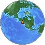
7.7 Mwp - QUEEN CHARLOTTE ISLANDS REGION
| Magnitude | 7.7 Mwp |
| Date-Time |
|
| Location | 52.769N 131.927W |
| Depth | 17 km |
| Distances |
|
| Location Uncertainty | Horizontal: 14.0 km; Vertical 4.0 km |
| Parameters | Nph = 716; Dmin = 267.2 km; Rmss = 0.95 seconds; Gp = 59° M-type = Mwp; Version = A |
| Event ID | us b000df7n |
For updates, maps, and technical information, see:
Event Page
or
USGS Earthquake Hazards Program
National Earthquake Information Center
U.S. Geological Survey
http://earthquake.usgs.gov/regional/neic/