Gulf Stream Diversion

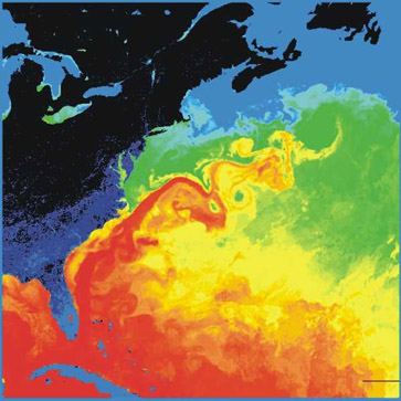
The Gulf Stream, together with its northern extension towards Europe, the North Atlantic Drift, is a powerful, warm, and swift Atlantic ocean current that originates at the tip of Florida, and follows the eastern coastlines of the United States and Newfoundland before crossing the Atlantic Ocean. It has flowed that way for a very long time and it does not seem likely to ever have a sudden change in direction. At a meeting with New England commercial fishermen last December, physical oceanographers Glen Gawarkiewicz and Al Plueddemann from the Woods Hole Oceanographic Institution (WHOI) were alerted by three fishermen about unusually high surface water temperatures and strong currents on the outer continental shelf south of New England. The result of his investigation was a discovery that the Gulf Stream diverged well to the north of its normal path beginning in late October 2011, causing the warmer-than-usual ocean temperatures along the New England continental shelf.
The researchers’ findings, "Direct interaction between the Gulf
Stream and the shelf break south of New England," were published in the
August 2012 issue of the journal Scientific Reports.
The Gulf Stream, along with similar warm air currents, helps keep
Ireland and the western coast of Great Britain a couple of degrees
warmer than the east. However, the difference is most dramatic in the
western coastal islands of Scotland. A noticeable effect of the Gulf
Stream and the strong westerly winds (driven by the warm water of the
Gulf Stream) on Europe occurs along the Norwegian coast. Northern parts
of Norway lie close to the Arctic zone, most of which is covered with
ice and snow in winter. However, almost all of Norway's coast remains
free of ice and snow throughout the year. Weather systems warmed by the
Gulf Stream drift into Northern Europe, also warming the climate behind
the Scandinavian mountains.
To begin to unravel the mystery, Gawarkiewicz and his colleagues
assembled data from a variety of sources and recreated a record of the
Gulf Stream path during the fall of 2011. First, they tapped into data
collected by a program called eMOLT, a non-profit collaboration of
fishing industry, research, academic and government entities, run by
James Manning of National Oceanic and Atmospheric Administration’s
Northeast Fisheries Science Center. For more than a decade the program
has recorded near-bottom ocean temperatures by distributing temperature
probes to lobstermen.
Manning and scientists from WHOI, including Robert Todd and Magdalena
Andres, analyzed a time series of temperatures from two eMOLT sites,
OC01 and TA51, which were located over the outer continental shelf near
the shelfbreak, and identified two events when temperatures suddenly
increased by 6.2 and 6.7°C, respectively, to highs of more than 18°C.
"These are very dramatic events for the outer continental shelf, at
least 2°C warmer than we’ve seen since 2001," says Gawarkiewicz.
"Near-bottom temperatures of 18°C on the outer shelf are extremely high
for late autumn." The maximum recorded temperature in December 2011 was
the warmest bottom temperature recorded in 6 years of records at the
OC01 site.
In typical years, the warm Gulf Stream waters only indirectly influence
ocean currents and temperatures near the continental shelf break south
of New England when eddies, called warm core rings, pinch off from the
Gulf Stream and drift toward the outer continental shelf. Such rings
normally drift past a site after a few weeks, and therefore cause only
limited warming of the water on the outer shelf.
The extent and duration of the two 2011 warming events combined with the
high salinity observed by the researchers suggested the cause was not a
transient warm core ring, but the Gulf Stream itself that carried warm,
salty water to the outer shelf.
To solidify that finding, Gawarkiewicz received help from students in
the Marine Advanced Technology Education (MATE) program at Cape Fear
Community College in Wilmington, NC, who had deployed a surface drifter
during the period coinciding with the two warming events. Drifters use
satellites to transmit their positions roughly every six hours, key
information for the WHOI scientists, who analyzed the drifter tracks and
speeds.
"Drifters around the edges of warm core rings drift toward the
continental shelf at about 1 knot," Gawarkiewicz says. "But we saw the
drifter cut across the slope towards the shelf at about 2.5 knots. It
only took it eight days to travel from Cape Fear, North Carolina, to a
point 40 miles south of Georges Bank, a total distance of 580 miles."
The periods of high speeds for the drifters coincided with the records
for high temperatures on the outer shelf, which told the scientists that
the core of the Gulf Stream had diverted to 39.9°N at 68°W — 125 miles
north of its mean position, further north than had ever been recorded by
satellite altimeters at this particular longitude.
The temporary shift in Gulf Stream path observed last fall potentially
has significant longer-term implications.
It is unclear what might have caused this shift in the Gulf Stream
path. It occurred shortly after Hurricanes Irene and Katia drenched the
east coast with rain, and this might have impacted the Gulf Stream
separation from the continental shelf near Cape Hatteras. Another
possibility is that a cold core ring, an eddy south of the Gulf Stream
core, might have deflected the Gulf Stream. Further research will be
necessary to determine exactly how and why this occurred, which will be
helpful in the long term in predicting Gulf Stream motions.
For further information see
Diversion.
Gulf Stream Map image via Wikipedia.
©2012. Copyright Environmental News Network To subscribe or visit go to: http://www.enn.com