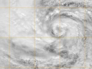
This GOES-13 satellite image provided by the
US Naval Research Laboratory shows the eye of
Hurricane Sandy it churns just off the eastern
coast of the US.
Photo Credit: AFP
October 28, 2012
What would you call an “unprecedented
and bizarre“ storm that is:
- The “largest hurricane in Atlantic
history measured by diameter of gale force
winds (1,040mi)” [Capital
Weather Gang]
- “A Storm Like No Other” [National
Weather Service via AP]. NWS: “I
cannot recall ever seeing model forecasts of
such an expansive areal wind field with
values so high for so long a time. We are
breaking new ground here.”
- “Transitioning from a warm-core
(ocean-powered) hurricane into an
extra-tropical low pressure system, a
classic Nor’easter, fed by powerful
temperature extremes and swirling jet stream
winds aloft to amplify and focus the storm’s
fury” [meteorologist Paul
Douglas]
- Being fueled in part by “ocean
temperatures along the Northeast U.S. coast
[] about 5°F above average,” so “there will
be an unusually large amount of water vapor
available to make heavy rain” [former
Hurricane Hunter Jeff
Masters]
- Also being driven by a high pressure
blocking pattern near Greenland “forecast to
be three standard deviations from the
average” [Climate
Central and CWG]
- “Stitched together from some spooky
combination of the natural and the
unnatural.” [Bill
McKibben]
McKibben explains “Our relationship to the
world around us is shifting as fast as that
world is shifting. ‘Frankenstorm’ is the
right name for Sandy, and indeed for many other
storms and droughts and heat waves now.”
CBS News offered another coincidental reason
for the name in its
headline, “Hurricane Sandy may slam into
U.S. East Coast as Halloween week
‘Frankenstorm’.”
Readers of my book, “Language
Intelligence: Lessons on Persuasion from Jesus,
Shakespeare, Lincoln, and Lady Gaga,”
know the unique power of metaphors. As one
review article put it, “Studies reveal that
virtually all of our abstract conceptualization
and reasoning is structured by metaphor.”
Frankenstein — and his monster — have become
a metaphor for the unintentional consequences of
scientific and technological advances.
Humans are changing the climate in dangerous
and unprecedented ways. At first it was
unintentional, but no one in the public arena
can possibly claim today they haven’t been
warned — repeatedly — by climate scientists and
others (see, for instance Lonnie
Thompson on why climatologists are speaking out:
“Virtually all of us are now convinced that
global warming poses a clear and present danger
to civilization.”)
Dr. Kevin Trenberth, former head of the
Climate Analysis Section at the U.S. National
Center for Atmospheric Research, explained in a
must-read 2012 review article in Climatic
Change:
The answer to the oft-asked question of
whether an event is caused by climate change
is that it is the wrong question. All
weather events are affected by climate
change because the environment in which they
occur is warmer and moister than it used to
be….
We can even make a stronger statement today
in the case of hurricanes thanks to a brand new
study, “Homogeneous
record of Atlantic hurricane surge threat since
1923”
We demonstrate that the major events in
our surge index record can be attributed to
landfalling tropical cyclones; these events
also correspond with the most economically
damaging Atlantic cyclones. We find
that warm years in general were more active
in all cyclone size ranges than cold years. The
largest cyclones are most affected by warmer
conditions and we detect a statistically
significant trend in the frequency of large
surge events (roughly corresponding to
tropical storm size) since 1923. In
particular, we estimate that
Katrina-magnitude events have been twice as
frequent in warm years compared with cold
years.
The name “Frankenstorm” fits. The unique
severity of the storm is the point! Manmade
warming has consequences. The time to act is
now.
For those who aren’t regular readers of
Climate Progress, here’s more of the literature
on how manmade carbon pollution is making many
of the most destructive kinds of extreme weather
events — Frankenstorms – more frequent and more
intense.
Let’s start with a quote from Jennifer
Francis of Rutgers (via
DotEarth) on the link between Sandy and the
record-smashing Arctic sea ice loss:
The jet stream pattern — particularly the
strongly negative NAO [North
Atlantic Oscillation] and
associated blocking — that has been in place
for the last 2 weeks and is projected to be
with us into next week is exactly the sort
of highly amplified (i.e., wavy) pattern
that I’d expect to see more of in response
to ice loss and enhanced Arctic warming.
Blocking happens naturally, of course, but it’s
very possible that this block may have been
boosted in intensity and/or duration by the
record-breaking ice loss this summer.
Late-season hurricanes are not unheard of
either, but Sandy just happened to come
along during this anomalous jet-stream
pattern, as well as during an autumn with
record-breaking warm sea-surface
temperatures off the US east coast. It
could very well be that general warming
along with high sea-surface temperatures
have lengthened the tropical storm season,
making it more likely that a Sandy could
form, travel so far north, and have an
opportunity to interact with a deep
jet-stream trough associated with the strong
block, which is steering it westward into
the mid-Atlantic. While it’s
impossible to say how this scenario might
have unfolded if sea-ice had been as
extensive as it was in the 1980s, the
situation at hand is completely consistent
with what I’d expect to see happen more
often as a result of unabated warming and
especially the amplification of that warming
in the Arctic.
I haven’t read the entire Noren paper
yet, but it does not surprise me that severe
flooding in the northeast could be linked
with periods of negative AO [Arctic
Oscillation]. When the AO is
negative, the jet stream tends to be wavier,
just like the situation we’re in now, which
favors slow-moving weather systems that can
cause floods. Losing ice, reducing the
poleward temperature gradient, and warming
the entire climate system should contribute
to increasing the likelihood of condusive to
anomalous storms.
The very latest science by Francis, NOAA, and
others suggests we may actually be in the midst
of a quantum leap or step-function change in
extreme weather because of increases in
“blocking patterns” and warming-driven Arctic
ice loss:
One of the basic predictions of climate
science is that extreme weather will make the
hydrological cycle more extreme:
1) Here we show that human-induced
increases in greenhouse gases have
contributed to the observed intensification
of heavy precipitation events found over
approximately two-thirds of data-covered
parts of Northern Hemisphere land areas.
These results are based on a comparison of
observed and multi-model simulated changes
in extreme precipitation over the latter
half of the twentieth century analysed with
an optimal fingerprinting technique.
Changes in extreme precipitation
projected by models, and thus the
impacts of future changes in extreme
precipitation, may be underestimated because
models seem to underestimate the observed
increase in heavy precipitation with
warming.
2) Occurring during the wettest
autumn in England and Wales since records
began in 1766 these floods damaged
nearly 10,000 properties across that region,
disrupted services severely, and caused
insured losses estimated at £1.3 billion….
… it is very likely that global
anthropogenic greenhouse gas emissions
substantially increased the risk of flood
occurrence in England and Wales in autumn
2000.
That post ended with its own review of the
literature on the connection between global
warming and extreme weather. Here are several
more recent studies on how warming is already
making our weather more extreme:
A new study by a Duke University-led team
of climate scientists suggests thatglobal
warming is the main cause of a significant
intensification in the North Atlantic
Subtropical High (NASH) that in recent
decades has more than doubled the frequency
of abnormally wet or dry summer weather in
the southeastern United States….
The models – known as Coupled Model
Intercomparison Project Phase 3 (CMIP3)
models – predict the NASH will
continue to intensify and expand as
concentrations of carbon dioxide and other
greenhouse gases increase in Earth’s
atmosphere in coming decades.”This
intensification will further increase the
likelihood of extreme summer precipitation
variability – periods of drought or deluge –
in southeastern states in coming decades,”
Li says.
The team calculates that a 1 ºC
increase in sea-surface temperatures would
result in a 31% increase in the global
frequency of category 4 and 5 storms per
year: from 13 of those storms to 17. Since
1970, the tropical oceans have warmed on
average by around 0.5 ºC. Computer models
suggest they may warm by a further 2 ºC by
2100.
-
Nature: Strong Evidence Manmade
‘Unprecedented Heat And Rainfall Extremes
Are Here … Causing Intense Human Suffering’
-
Hansen et al: “Extreme Heat Waves … in
Texas and Oklahoma in 2011 and Moscow in
2010 Were ‘Caused’ by Global Warming”
-
Study Finds 80% Chance Russia’s 2010
July Heat Record Would Not Have Occurred
Without Climate Warming
-
NOAA: Human-Caused Climate Change Already a
Major Factor in More Frequent Mediterranean
Droughts
Manmade climate change is one monster we
still have some control over. But here’s the
final warning. We are already seeing
Frankenstorms, and we’ve only warmed about 1.4°F
over the past century. We are on track to see
more than 5 times that warming this century. The
monster storms that would spawn are beyond
imagining.
http://www.alternet.org/environment/why-hurricane-sandy-has-morphed-frankenstorm-and-why-we-should-get-used-catastrophic?akid=9601.138978.Q4mAir&rd=1&src=newsletter734886&t=6&paging=off