3-D Mapping Of Isaac Water Levels
September 1, 2012
A new
technology was deployed by U.S. Geological Survey scientists to map
urban flooding caused by Hurricane Isaac. Called “terrestrial
lidar,” or “T-lidar”, this new capability will enable scientists to
collect highly detailed information in select population areas in
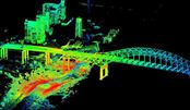
The portable instrument allows scientists
to quickly generate 3-D maps of buildings, dams, levees and other
structures, and can show areas of storm damage as well. In a
four-to-five minute scan, the instrument collects millions of
topographic data points in a full 360-degree view to quickly produce
highly accurate topographic information and can map areas up to
two-thirds of a mile away.
The information gathered from this pilot
project will be used by USGS to develop 3-D models of streets and
structures, including the levels floodwaters reached, as well as
current water levels in the form an interactive 3-D flood inundation
map. The map will help identify where the potential threat of
future floodwaters is greatest, and will help determine the extent
of wind and flood damages caused by Isaac.
"If a picture paints a thousands words, a
T-lidar scan paints several million words to capture the fleeting
aftermath of a hurricane's impact," said USGS Director Marcia
McNutt. "The ability to rapidly preserve for posterity a
quantifiable, three-dimension representation of storm damage is
going to open the doors for new flood hazard science."
T-lidar looks sideways from ground level,
enabling it to capture vertical details, such as water levels, that
airborne lidar cannot. This enables it to capture the extent
of flooding. The USGS will be using both a tripod mounted and
a truck-mounted version. While the tripod version takes
individual scans from multiple locations that later have to be
combined to develop its 3-D maps, the truck-mounted version is
continuously collecting information that is available almost
immediately.
"Using terrestrial lidar in this fashion has
the possibility of helping us quickly assess high-water marks,
current water levels, and to some degree flood damage, in a very
short time," said Athena Clark, director of the
"Lidar" stands for "light detection and
ranging." Where "radar" uses radio waves as a form of
measurement, "lidar" uses light. Terrestrial lidar, sometimes
called “terrestrial laser scanning,” uses a sensor that emits laser
pulses and measures distance by how long it takes the reflected
laser beam to "bounce back" to the instrument. TLS can provide very
precise data, to millimeter accuracy, to enable scientists to build
high-resolution 3-D models of objects.
"We are collecting storm-tide information
that will allow scientists to study the impacts of the storm in
three dimensions," said Toby Minear, a research hydrologist at the
In addition to the use of terrestrial lidar,
the USGS is also planning airborne lidar flights to assess the level
of coastal change caused by Isaac along the
SOURCE: U.S. Geological Survey
Copyright © 1996 - 2012, VertMarkets, Inc. All rights reserved. To subscribe or visit go to: http://www.wateronline.com