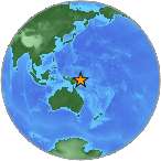
6.4 - NEW IRELAND REGION, PAPUA NEW GUINEA
| Magnitude | 6.4 |
| Date-Time |
|
| Location | 3.920S 152.127E |
| Depth | 17 km |
| Distances |
|
| Location Uncertainty | Horizontal: 14.3 km; Vertical 6.5 km |
| Parameters | Nph = 95; Dmin = 30.4 km; Rmss = 0.58 seconds; Gp = 25° Version = 7 |
| Event ID | us b000gen8 |
For updates, maps, and technical information, see:
Event Page
or
USGS Earthquake Hazards Program
National Earthquake Information Center
U.S. Geological Survey
http://earthquake.usgs.gov/regional/neic/