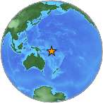
6.2 - SANTA CRUZ ISLANDS REGION
| Magnitude | 6.2 |
| Date-Time |
|
| Location | 11.664S 164.960E |
| Depth | 9 km |
| Distances |
|
| Location Uncertainty | Horizontal: 16.5 km; Vertical 5.8 km |
| Parameters | Nph = 244; Dmin = 600.8 km; Rmss = 0.62 seconds; Gp = 55° Version = 8 |
| Event ID | us c000f2ul |
For updates, maps, and technical information, see:
Event Page
or
USGS Earthquake Hazards Program
National Earthquake Information Center
U.S. Geological Survey
http://earthquake.usgs.gov/regional/neic/