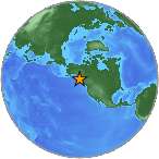
7.7 Mwp - SOUTHEASTERN ALASKA
| Magnitude | 7.7 Mwp |
| Date-Time |
|
| Location | 55.292N 134.728W |
| Depth | 9 km |
| Distances |
|
| Location Uncertainty | Horizontal: 12.3 km; Vertical 4.4 km |
| Parameters | Nph = 362; Dmin = 103.8 km; Rmss = 1.14 seconds; Gp = 129° M-type = Mwp; Version = 7 |
| Event ID | us c000ejqv |
For updates, maps, and technical information, see:
Event Page
or
USGS Earthquake Hazards Program
National Earthquake Information Center
U.S. Geological Survey
http://earthquake.usgs.gov/regional/neic/