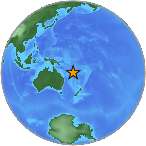
6.1 - VANUATU
| Magnitude | 6.1 mb |
| Date-Time |
|
| Location | 17.771S 167.341E |
| Depth | 15 km |
| Distances |
|
| Location Uncertainty | Horizontal: 16.8 km; Vertical 5.2 km |
| Parameters | Nph = 275; Dmin = 417.4 km; Rmss = 0.71 seconds; Gp = 30° M-type = mb; Version = B |
| Event ID | us c000fe8q |
For updates, maps, and technical information, see:
Event Page
or
USGS Earthquake Hazards Program
National Earthquake Information Center
U.S. Geological Survey
http://earthquake.usgs.gov/regional/neic/