The Seven Most Alarming Effects of Climate Change on North America, 2013 Edition
The subject of climate change figured prominently in President Obama’s State of the Union address on February 12. The President called for Congress to “pursue a bipartisan, market-based solution to climate change.” All well and good, but waiting for Congress to fix climate change is like waiting for Congress to resolve, say, its budget debates. It’s the kind of gridlock that will just send more CO2 pouring into the atmosphere.
While it’s clear to just about everyone at this point that Mother Earth is out of balance, perhaps it is difficult to galvanize mainstream Americans (and the U.S. Congress) with bureaucratic-sounding terms such as climate change. There are better ways of describing what it will be like to have eight feet of water flooding your first floor—such as describing what it has been like to actually have eight feet of water flooding homes. If the past is any guide, we have a lot to look forward to on Turtle Island in 2013—none of it good. Here are the Seven Most Alarming Effects of Climate Change on North America, 2013 Edition.
1) More Wildfires
The year 2012 was the hottest on record in the contiguous United States since satellite recordkeeping began in 1979, according to the National Oceanic and Atmospheric Administration (NOAA). January has continued the trend.
Last summer, two-thirds of the contiguous United States was gripped in the most severe drought since the 1950s. January 2013 proved warmer and wetter than 20th-century averages. Average temperature was 1.6 degrees above the average for last century and tied with 1958 as the 39th warmest January on record, NOAA said on February 14. And precipitation totaled 2.36 inches nationwide on average, 0.14 inch above the long-term average, NOAA said.
“The January precipitation average masked both wet and dry extremes across the nation,” NOAA said in a statement on February 14. “Drought conditions remained entrenched across the Southeast, Great Plains, and the mountainous West.”
On the ground, it means harder times for farmers and ranchers. It could also mean higher food prices for the rest of us.
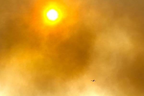
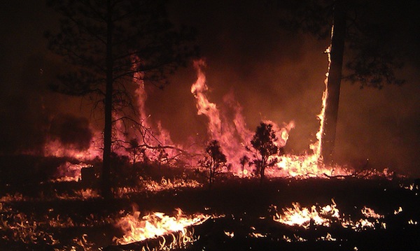
The hotter temperatures are contributing to a plethora of wildfires, more and more of which we can expect to see, especially in the western United States and throughout Indian country. This means longer fire seasons, drier conditions, more forest-fire fuel (caused partly by widespread beetle infestations that have created dead, highly combustible trees ready for a spark) and increased lightning frequency due to more severe thunderstorms, according to the World Wildlife Federation.
Wildfires swept the U.S. West and Southwest in 2011 and 2012, the worst seasons on record. In Indian country that translated into damage or outright devastation on several reservations, including the Northern Cheyenne Indian Reservation, where the 2,000-population town of Lame Deer, the tribal hub, was briefly evacuated in August 2012 after a fire in southeastern Montana made its way onto the reservation. In New Mexico, the Whitewater-Baldy Fire—the largest wildfire in that state’s history—destroyed the habitat of the Gila trout, which had to be relocated. Other fires in the state threatened the San Carlos Apache and Fort Apache reservations. In all, hundreds of thousands of acres were destroyed.
What will this year bring? It’s too dreadful to contemplate, but tribal forestry agents from Arizona and New Mexico to the Canadian border are on alert.
2) Less Water in Great Lakes
Last summer the Mississippi River had to be closed to shipping for days because the water was too low to allow barges to pass.
Now, two of the Great Lakes that border the U.S. and Canada, Lake Michigan and Lake Huron, are lower than ever recorded, according to a new study from the U.S. Army Corps of Engineers. This is doing everything from wreaking havoc on the tourism industry and other economic ventures that depend on the waters, to causing concerns about the fate of freshwater reserves in the future, as National Public Radio reported recently. The other Great Lakes are below average as well. Warmer temperatures and less ice coverage both cause the water to evaporate, said Alan Steinman, director of the Annis Water Resource Institute, to Public Radio International.
"Lower precipitation overall has contributed as well," he said. "A lot of people have suggested that it may be because we're taking more water out of the lakes, but that's really a very small percentage of the total water budget, it's more associated with climate."
Less water in the North Country can prove disastrous to traditional ways of life. Last year, for only the second time in 10 years, the manoomin (wild rice) harvest of the Ojibwe Bad River Reservation in northern Wisconsin was canceled, as was the harvest of the Fond du Lac Band of Lake Superior Chippewa near Duluth, Minnesota. Factors related to climate change were thought to be at least part of the culprit in both harvests, said Peter David, wildlife biologist at the Great Lakes Indian Fish & Wildlife Commission (GLIFWC) to ICTMN at the time. “It seems that we are having more bad years for rice,” he said.
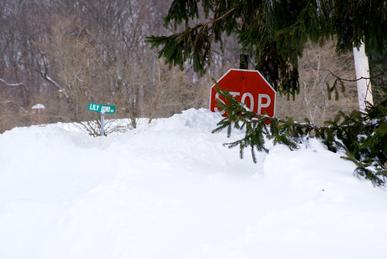
3) More Flooding in the Northwest
Elsewhere the problem is too much water. A single description sticks in the mind of Senator Maria Cantwell (D-Wash.) that sums up what’s happening with water in the Pacific Northwest. Speaking to tribal leaders and representatives from around the country at the National Congress of the American Indians’ State of the Indian Nations Address on February 14, she said it’s already happening. “I’ll never forget when I had one of the Quileutes testify before the Senate Indian Energy Committee,” Cantwell said. “I asked them how close they were to the Pacific Ocean and they said, ‘Well sometimes it’s right out the back door. And sometimes it’s right under the window.’ ”
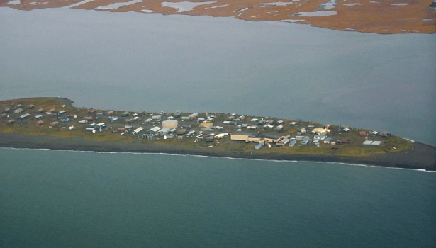
It’s well known that the tiny village of Kivalina, Alaska, has had to relocate as water covers its original ground. But the same thing is happening throughout the continental northwestern United States as well. Rising sea levels in the Northwest have been an issue for years for tribes in Washington, specifically the Quileute and Hoh. Both have been losing reservation lands to the rising sea levels, and for the Quileute half the reservation lies in a floodplain that sits 15 feet above sea level. On October 25, 2012, federal legislation transferred 772 acres of Olympic National Park, which borders the Quileute’s reservation on three sides, to the tribe.
The Hoh reservation sat on one square mile of land, 90 percent of which was in a flood plain and 100 percent in a tsunami zone. The reservation is situated on the banks of the Hoh River where it meets the Pacific Ocean. Legislation introduced by senators Cantwell and Patty Murray (D-Wash.) allowed the tribe to move out of the flood plain and tsunami zone.
Effects go beyond the two tribes. According to a 2009 report by The Pacific Institute, The Impacts of Sea-Level Rise on the California Coast, some 480,000 people along the California coast are at an increased risk along with nearly copy00 billion (in year 2000 dollars) worth of existing property from flooding, with a 1.4-meter sea-level rise. “Over the past century, mean sea level has risen nearly eight inches at the Golden Gate in San Francisco, according to NOAA oceanographers, and under a medium-to-medium-high greenhouse-gas emissions scenario, mean sea level is projected to rise from 1.0 to 1.4 meters (or 4-5 feet) by the year 2100,” the institute said in a statement when the report was released.
4) Nastier Nor’Easters
If you live on the East Coast maybe you’ve noticed a change in the weather over the past few years, particularly nor’easters and hurricanes. Do the names Irene, Sandy and Nemo ring a bell?
It’s no secret that the northeastern United States has been beset by severe blizzards in recent years. More than the snow, which melted relatively quickly, the storms were notable, like Superstorm Sandy, for being composed of colliding systems of varying temperatures and participation types. The blizzard that dumped three feet or more of snow on New England, New York, eastern Long Island and parts of New Jersey on the weekend of February 8 was a prime example.
According to the Environmental Protection Agency, the severe weather changes could be thanks to climate change. The agency says that since 1970, the average temperature in the Northeast has increased by two degrees Fahrenheit. and the average winter temperature has gone up by four degrees. The agency’s website on climate change also says that heavy precipitation events have increased in magnitude and frequency, and scientists expect these trends to continue.
The Union of Concerned Scientists agrees. The group’s recent post “It’s Cold and My Car is Buried in Snow. Is Global Warming Really Happening?” says that while residents on the North Atlantic coast are used to winter storms, climate change will make those storms worse and more frequent.
“Rising ocean surface temperatures already have increased the temperature and moisture content of the air passing over the United States, setting the stage for heavier snow and rain storms. Global warming has increased the risk of dumping heavier precipitation—as rain or snow—over most land regions that experience storms,” climate scientist Brenda Ekwurzel, who is with the union, told the Huffington Post.
“In the U.S., the region that has experienced the highest increase in heaviest precipitation is the Northeast over the last half century,” she continued. “According to NOAA [National Oceanic and Atmospheric Administration], the Northeast saw a 74 percent increase in the amount of precipitation that fell during the heaviest rain and snow events between 1958 and 2011.”
The administration created a graph showing Northeast extremes in which the spikes are pretty evident from 1911 to 2012.
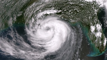
5) Stronger Hurricanes
Aside from Superstorm Sandy and how far north it came—wreaking destruction on a scale that we usually associate with the tropics—there have been severe storms, too, in the Southeast. Hurricanes such as the August 2012 Isaac have prompted the evacuation of hundreds in communities of the Houma Tribe in Louisiana, for instance, and even threaten the very existence of some smaller tribes along the Gulf coast. This is part of the same phenomenon that is affecting the Northeastern and Midwestern snowstorms.
“What it’s telling us is that we have more moisture in the atmosphere because the climate is warmer because the ocean temperatures are warmer,” Andrew Freeman, a senior writer at Climate Central, explained to Mike Sacks of HuffPost Live about the graph.
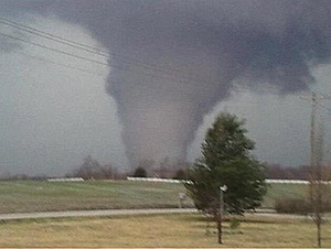
6) Wilder Tornados
Last year nearly 1,000 tornadoes were confirmed in the United States, many of them cutting widespread swathes of destruction through the Midwest. The year 2011 saw the Choctaw Tribe mobilizing to assist tribal members as well as non-Natives after devastating twisters throughout Oklahoma and Missouri. The Cherokee Nation also saw widespread damage. And later that summer after similar weather hit Alabama, the unscathed Poarch Tribe donated $500,000 to tornado relief throughout the state. Although tornadoes are the least attributable to climate change, according to The New York Times, their frequency and intensity show no signs of abating.
7) More West Nile Virus
Global warming likely triggered the spread of the West Nile virus in the drought-plagued south in 2012. In September, The New York Times reported the West Nile virus had killed 118 people so far in 2012 and infected another 3,000 nationwide. Texas and Oklahoma suffered the brunt of the heat and the virus’s wrath with cases of infection and death spiking in August. Dallas County was the hardest-hit county in the United States; the virus cost the lives of dozens of people, from those in their 40s to 90 and higher.

While scientists are still researching the culprit, all signs point to the scorching weather, and hence, climate change. Intense heat increased the prevalence of mosquitoes, which contracted the virus while feeding on infected birds. Scientific American reported that studies show mosquitoes pick up the virus more readily in higher temperatures, and they are more likely to transmit the virus to humans when it’s hotter. Environmental conditions are also likely to blame for the larger population of susceptible birds and mosquitoes, the Times noted.
Read more at http://indiancountrytodaymedianetwork.com/2013/02/22/seven-most-alarming-effects-climate-change-north-america-2013-edition-147835
© 1998 - 2013 Indian Country Today. All Rights Reserved To subscribe or visit go to: http://www.indiancountry.com