USGS Releases New Oil and Gas Assessment for Bakken
and Three Forks Formations
The Bakken and Three Forks Formations contain an
estimated mean of 7.4 billion barrels of undiscovered,
technically recoverable oil. The updated assessment for
the Bakken and Three Forks represents a twofold increase
over what has previously been thought. These two
formations are also estimated to contain a mean of 6.7
trillion cubic feet of undiscovered, technically
recoverable natural gas and 0.53 billion barrels of
undiscovered, technically recoverable natural gas
liquids, a threefold increase for both resources.
The geological foundation that underpins the assessment
was facilitated by data provided by the North Dakota
Geological Survey, North Dakota Industrial Commission,
Montana Board of Oil and Gas, and multiple industry
groups working in this region. This new information and
data allowed USGS to develop a more robust geologic
model and understanding of the petroleum system of the
Bakken and Three Forks Formations.
USGS Releases New Oil and Gas Assessment for Bakken and
Three Forks Formations
The Bakken and Three Forks Formations contain an estimated
mean of 7.4 billion barrels of undiscovered, technically
recoverable oil. The updated assessment for the Bakken and
Three Forks represents a twofold increase over what has
previously been thought. These two formations are also
estimated to contain a mean of 6.7 trillion cubic feet of
undiscovered, technically recoverable natural gas and 0.53
billion barrels of undiscovered, technically recoverable
natural gas liquids, a threefold increase for both
resources.
The geological foundation that underpins the assessment was
facilitated by data provided by the North Dakota Geological
Survey, North Dakota Industrial Commission, Montana Board of
Oil and Gas, and multiple industry groups working in this
region. This new information and data allowed USGS to
develop a more robust geologic model and understanding of
the petroleum system of the Bakken and Three Forks
Formations.
Department of the Interior Press Release (4/30/13)
USGS 2013 Assessment Fact Sheet
USGS Science Article
Bakken FAQs
Bakken Media Gallery
List of Assessments and Related Links
|
|
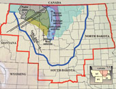
Map showing the Williston Basin
Province and Bakken TPS.
|
|
|
|
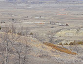
North Dakota Badlands with
Bakken oil pads in the distance. |
|
|
|
|
News and Publications
.................................................................
Technical Announcement
New Insight on Gas Hydrates in Gulf of Mexico
Research is Part of a Long-Standing, Interagency
Collaboration
Scientists have returned from a 15‑day research
expedition in the northern Gulf of Mexico with the best
high-resolution seismic data and imagery ever obtained
of sediments with high gas hydrate saturations.
The expedition and the data and imagery collected
resulted from long-standing cooperation between the U.S.
Department of the Interior's U.S. Geological Survey
(USGS) and Bureau of Ocean Energy Management (BOEM) and
the U.S. Department of Energy (DOE). This collaboration
aims to advance scientific understanding of gas
hydrates, an important potential future energy
resource.
|
|