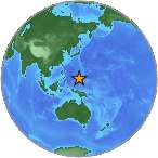
6.0 - MARIANA ISLANDS REGION
| Magnitude | 6.0 |
| Date-Time |
|
| Location | 12.298N 141.678E |
| Depth | 109 km |
| Distances |
|
| Location Uncertainty | Horizontal: 0.0 km; Vertical 4.6 km |
| Parameters | Nph = 161; Dmin = 374.5 km; Rmss = 0.95 seconds; Gp = 15° Version = |
| Event ID | us b000k7q5 |
For updates, maps, and technical information, see:
Event Page or USGS
Earthquake Hazards Program
National Earthquake Information Center
U.S. Geological Survey
http://earthquake.usgs.gov/regional/neic/
Disclaimer
Due to a lapse in Federal funding, the USGS Earthquake Hazards Program has suspended most of its operations. While the USGS will continue to monitor and report on earthquake activity, the accuracy or timeliness of some earthquake information products, as well as the availability or functionality of some web pages, could be affected by our reduced level of operation.