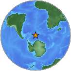
6.2 - EAST OF THE SOUTH SANDWICH ISLANDS
| Magnitude | 6.2 |
| Date-Time |
|
| Location | 58.240S 12.943W |
| Depth | 30 km |
| Distances |
|
| Location Uncertainty | Horizontal: 0.0 km; Vertical 4.7 km |
| Parameters | Nph = 34; Dmin = 1517.6 km; Rmss = 1.35 seconds; Gp = 61° Version = 1 |
| Event ID | us c000kmfw |
For updates, maps, and technical information, see:
Event Page or USGS
Earthquake Hazards Program
National Earthquake Information Center
U.S. Geological Survey
http://earthquake.usgs.gov/regional/neic/
Disclaimer