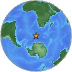
6.9 - BOUVET ISLAND REGION
| Magnitude | 6.9 |
| Date-Time |
|
| Location | 53.527S 8.704E |
| Depth | 11 km |
| Distances |
|
| Location Uncertainty | Horizontal: 0.0 km; Vertical 4.4 km |
| Parameters | Nph = 47; Dmin = 2102.1 km; Rmss = 1.06 seconds; Gp = 35° Version = B |
| Event ID | us b000pkxl |
For updates, maps, and technical information, see:
Event Page or USGS
Earthquake Hazards Program
National Earthquake Information Center
U.S. Geological Survey
http://earthquake.usgs.gov/regional/neic/