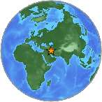
6.2 - IRAN-IRAQ BORDER REGION
| Magnitude | 6.2 |
| Date-Time |
|
| Location | 32.739N 47.670E |
| Depth | 10 km |
| Distances |
|
| Location Uncertainty | Horizontal: 0.0 km; Vertical 1.7 km |
| Parameters | Nph = 105; Dmin = 1031.5 km; Rmss = 1.11 seconds; Gp = 40° Version = |
| Event ID | us b000s3np |
For updates, maps, and technical information, see:
Event Page or USGS
Earthquake Hazards Program
National Earthquake Information Center
U.S. Geological Survey
http://earthquake.usgs.gov/regional/neic/
Disclaimer
For current space weather conditions please refer to:
http://www.swpc.noaa.gov/NOAAscales/index.html#SolarRadiationStorms NOAA Space Weather Scale descriptions can be found at
www.sec.noaa.gov/NOAAscales