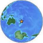
6.6 - SOUTH OF THE KERMADEC ISLANDS
| Magnitude | 6.6 |
| Date-Time |
|
| Location | 32.904S 177.817W |
| Depth | 19 km |
| Distances |
|
| Location Uncertainty | Horizontal: 0.0 km; Vertical 4.0 km |
| Parameters | Nph = 105; Dmin = 406.0 km; Rmss = 1.41 seconds; Gp = 24° Version = 1 |
| Event ID | us c000mfm0 |
For updates, maps, and technical information, see:
Event Page or USGS
Earthquake Hazards Program
National Earthquake Information Center
U.S. Geological Survey
http://earthquake.usgs.gov/regional/neic/
Disclaimer