Researchers bring extensive world temperature records to Google Earth
By Darren Quick
February 6, 2014

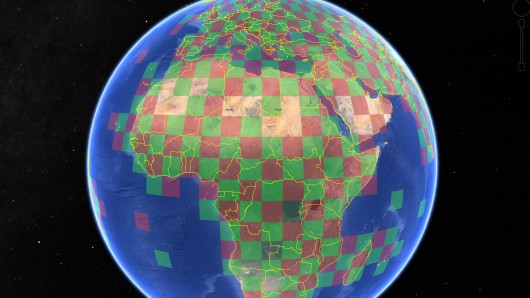
The CRUTEM4 dataset provides Google Earth users with access to one of the most widely used records of Earth's climate
Talking about the weather is a pastime as old as language, but climate researchers from the University of East Anglia (UEA) in the UK have just given people a whole lot more to talk about. As part of an ongoing effort to increase the accessibility and transparency of data on past climate and climate change, they've made one of the most widely used records of Earth's climate accessible through Google Earth.


Established in 1971, the UEA's Climate Research Unit (CRU) has become one of the leading institutions involved in the study of natural and anthropogenic climate change. Drawing on monthly weather records from some 6,000 weather stations around the globe, some dating back over 150 years, the researchers are responsible for Climatic Research Unit Temperature Version 4 (CRUTEM4), a widely used dataset of land-surface air temperatures.
By making CRUTEM4 data available through Google Earth, users can zoom in on any of the 6,000 weather stations, drill down through some 20,000 graphs and view monthly, seasonal and annual temperature data, some of which dates back to 1850. The interface places a red and green checkerboard over areas for where data is available. Since some remote areas lack weather stations, there are gaps in the checkerboard.
"The data itself comes from the latest CRUTEM4 figures, which have been freely available on our website and via the Met Office," said Dr Tim Osborn from the CRU. "But we wanted to make this key temperature dataset as interactive and user-friendly as possible. The beauty of using Google Earth is that you can instantly see where the weather stations are, zoom in on specific countries, and see station datasets much more clearly."
There are already a number of climate datasets available for Google Earth, including those from the US National Oceanic and Atmospheric Administration (NOAA). Those wishing to view these and the CRUTEM4 dataset need only download Google Earth and open the KML format files. Due to the sheer volume of data, the CRU researchers expect there will be a few errors in their dataset and are encouraging users to alert them to any unusual figures.
Source: University of East Anglia
Copyright © gizmag 2003 - 2014 To subscribe or visit go to: http://www.gizmag.com