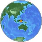
6.9 - MOLUCCA SEA
| Magnitude | 6.9 |
| Date-Time |
|
| Location | 2.230N 127.085E |
| Depth | 48 km |
| Distances |
|
| Location Uncertainty | Horizontal: 0.0 km; Vertical 6.3 km |
| Parameters | Nph = 177; Dmin = 164.4 km; Rmss = 1.31 seconds; Gp = 20° Version = |
| Event ID | us b000syhz |
For updates, maps, and technical information, see:
Event Page or USGS
Earthquake Hazards Program
National Earthquake Information Center
U.S. Geological Survey
http://earthquake.usgs.gov/regional/neic/
Disclaimer