Seven months after Malaysia Airlines Flight 370 vanished, searchers continue to hunt for the missing aircraft.
But, while experts carry out an unprecedented search for the plane’s wreckage, other discoveries are being made. Moreover, officials say that it is possible the hunt for MH370 will also solve other decades-old mysteries.
TheBlaze spoke with Dr. Stuart Minchin, the chief of the environmental geoscience division at Geoscience Australia, who delved into such information.
The Search

Multibeam sonar is being used to map the sea ocean floor. Image is for illustrative purposes only. NOAA vessels are not involved in the search. (Image source: National Oceanic and Atmospheric Association)
The Australian Transport Safety Bureau, the agency leading the search for the missing plane, has split the operation into two phases.
Phase one calls for a bathymetric survey of the ocean floor, which will provide experts with a map depicting the seafloor’s topography.
Minchin explained to TheBlaze the technology his team is using to produce such a map.
He said the team is employing multibeam sonar that sends out a ping and measures the amount of time it takes for the sound save to travel to the ocean floor. This provides searchers not only an idea of how deep the seabed is, but also what they may find on it.
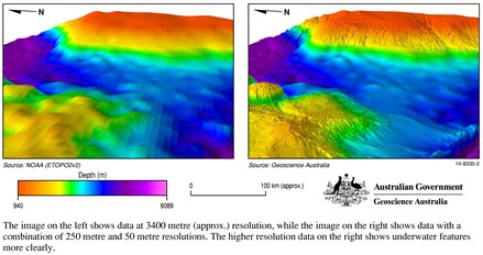
Figure 1: The image on the left shows data at around 3400-metre resolution (data acquired predominantly by satellite altimetry), while the image on the right shows data with a combination of 250-metre and 50-metre resolutions (data acquired by bathymetric surveys from a vessel). (Image source: ATSB)
“We are able to distinguish hard areas from soft areas,” Minchin said. “We are routinely identifying places that are harder than the surrounding surfaces. In most cases, they are likely to be rocks, but it also might be a signature of a shipwreck or debris or an airplane.”
Once phase one is completed and the seafloor is mapped, searchers will move to the second phase which will utilize other equipment, such as submersible vehicles, to examine identified areas of interest in hopes of finding the wreckage of MH370.
Unintended Discoveries
While Minchin and his team work to map the seabed of the Indian Ocean in the hunt for the missing plane, they are also making unintended discoveries about the sea floor.
“We are seeing features on the sea floor that were not known to be there previously,” Minchin told TheBlaze. “Things like remnant volcanoes, ridges and quite reasonably sized mountains that were not visible in the previous biometric knowledge of the area.”

These three-dimensional models of the sea floor terrain have been developed from high resolution (90 metre grid) bathymetric data from the survey in the southern part of the Indian Ocean. (Image source: ATSB)
“These features are of great interest,” he continued. “These are sites where there might be collections of biological communities worth looking at in the future.”
Minchin stressed that while they are chiefly looking for the missing Malaysia Airlines flight, the collected data “in due course” will be made available to the broader scientific community.

These three-dimensional models of the sea floor terrain have been developed from high resolution (90 metre grid) bathymetric data from the survey in the southern part of the Indian Ocean. (Image source: ATSB)
“The depth of the ocean and things like sea mountains and ridges play a major role in defining the habitats underwater,” he said. “Biological communities depend on the pressure and temperature of the water, which are all dependent on the depth — so it is quite common for sea communities to gather around places that are a lot shallower.”
“This data provides interest in locations we may go back in the future and examine more closely,” he added.

This map shows bathymetry data acquired in the search for missing Malaysia Airlines flight 370. This data is crucial as it provides information on the seabed terrain to ensure the underwater search equipment can be operated safely. (Image source: ATSB)
Describing the images of the typography as “quite visually spectacular,” Minchin also noted that the new maps also correct old, outdated ones.
“We’re seeing quite large differences in the depth that we previously thought were in some of these locations and what we are actually measuring,” he told TheBlaze. “Sometimes, its differences in depth are up to one-and-a-half kilometers and that is really important in understanding this area.”
Locating Other Wreckage?
Minchin said that while his team is primarily focused on finding MH370, they are also keeping a watchful eye for other possible wreckage.
“We are aware that there are a number of ships that went missing during World War II in the Indian Ocean,” he told TheBlaze. “The exact location of them is unknown.”
At the moment, he said it’s “hard to really state” whether or not some of the hard areas identified in phase one may be the ships, but phase two should provide more information.
“It’s possible we’ll find some of the wreckage down there as part of the search,” he said.
—
Follow Oliver Darcy (@oliverdarcy) on Twitter
© 2014 TheBlaze Inc