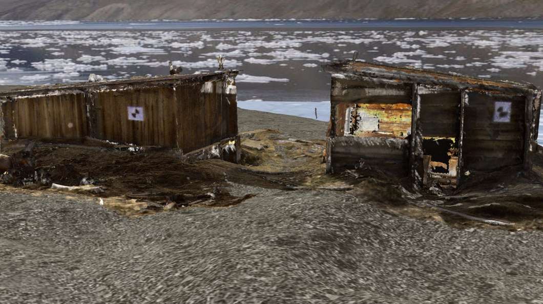
Nobody knows exactly how climate change will play out in the coming decades, but the Poles are already being affected as ice melts away. Man-made sites in the region are also under threat as ice vanishes and, because of this, a Canadian researcher is on a mission to visually record one place that could soon become just a memory.


Peter Dawson, an archaeology professor at the University of Calgary, has received funding from the Canada Foundation for Innovation (CFI) to preserve on digital media a place called Fort Conger. This remote site in Quttinirpaaq National Park on Ellesmere Island in the Canadian Arctic Archipelago is likely to vanish along with the melting permafrost upon which it sits. To virtually preserve it, Dawson is using a 3D digital scanner to capture the area and its features.
"Fort Conger is a very important place of both national and international significance," Dawson says. "Melting permafrost is causing the surface area to sink and erode and that's damaging the wooden buildings."
CFI has awarded Dawson with a CAD51,000 (US$38,700) grant to purchase his own scanner as he’s been using a borrowed device since 2010. In the (Northern Hemisphere) summer of that year, he pioneered the use of a laser scanner in the region and started a collection of images.
The new equipment will enable Dawson to continue his work and monitor the site. The small device, which hasn't been purchased yet, is as small as a lunchbox, and can be screwed on top of a tripod to capture high-resolution images. It rotates 360 degrees and emits beams of laser light millions of times a minute. It then measures the time it takes the beam to hit the surface of the target subject and return to the scanner.
"Using 3D scanning data to capture the rapidly changing face of these world heritage sites, in the face of natural processes and human activities, offers a way of encapsulating a baseline so that conservation and restoration work can be planned from the resulting 3D models," says Dawson. "The 3D models created from laser scanning data can also be used to excite public interest in cultural stewardship and Arctic history."
The history of the fort goes back to 1875 when British Explorers were trying to get to the North Pole. After that, it became the scientific headquarters of the Lady Franklin Bay Expedition during the First International Polar Year (1882-83). Later, American Polar Explorer Robert Peary also used the site for his controversial quest to reach the North Pole.
The Lady Franklin Bay Expedition left a legacy of inorganic contaminants, such as arsenic, copper, lead, zinc, and polycyclic aromatic hydrocarbons, which also threaten the site. These substances were used for maintaining scientific instruments used at the time and to preserve specimens.
Besides the melting ice and the legacy contaminants, there’s a contemporary human threat to the site as well. With less ice, the region will become accessible to tourism and there will be people wandering around the site and potentially damaging it in the process. The research is part of a bigger drive to understand the impacts of climate change on northern people.
Images and information of Fort Conger are already available online on the CyArk website, a collaborative platform dedicated to heritage sites.
Source: University of Calgary, Ocean Portal
http://www.gizmag.com/fort-conger-digital-record-climate-change/38741/