What is the Ring of Fire?
There are more than 450 active and dormant volcanoes located within the Ring of Fire. Plus it’s prone to powerful earthquakes. Here’s why.
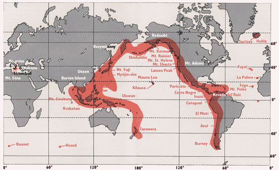
Many volcanoes on Earth are located around the Pacific Ring of Fire. Image Credit: U.S. Geological Survey.
The Ring of Fire is a long chain of volcanoes and other tectonically active structures that surround the Pacific Ocean. The chain runs up along the western coast of South and North America, crosses over the Aleutian Islands in Alaska, runs down the eastern coast of Asia past New Zealand and into the northern coast of Antarctica. The Ring of Fire is one of the most geologically active areas on Earth, and is a site for frequent earthquakes and powerful volcanic eruptions.
There are more than 450 active and dormant volcanoes located within the Ring of Fire. Many of these volcanoes were created through the tectonic process of subduction whereby dense ocean plates collide with and slide under lighter continental plates.
The material from the ocean floor melts as it enters the Earth’s interior and then rises to the nearby surface as magma. Noteworthy volcanoes that dot the Ring of Fire include Mount St. Helens in the USA, Mount Fuji in Japan and Mount Pinatubo in the Philippines. Since 1850, approximately 90% of the 16 most powerful volcanic eruptions on Earth have occurred within the Pacific Ring of Fire.

Image of an oceanic plate being subducted under a continental plate. Image Credit: U.S. Geological Survey.
Deep ocean trenches are a common feature of the Ring of Fire. These trenches form along subduction zones where slabs of the ocean floor slide into the Earth. The deepest part of the ocean on Earth, the Mariana Trench, is located along the Ring of Fire in the western portion of the Pacific Ocean Basin.
The majority of Earth’s earthquakes occur in the Ring of Fire, too. These earthquakes are caused by the sudden lateral or vertical movement of rock along plate margins. About 81% of the world’s largest earthquakes have occurred along the Ring of Fire. The largest earthquake ever recorded on Earth was a 9.5 magnitude earthquake that struck Chile on May 22, 1960. Other noteworthy earthquakes that have occurred along the Ring of Fire include a 9.2 magnitude earthquake that struck Prince William Sound, Alaska on March 28, 1964, a 9.1 magnitude earthquake that struck off the coast of Sumatra on December 26, 2004 and a 9.0 earthquake that struck near the coast of Honshu, Japan on March 11, 2011.

A September 2010 eruption of Mount Yasur in Vanuatu. Image appears courtesy of Tom Pfeiffer, Volcano Discovery.
Despite the high levels of volcanic and seismic activity, millions of people live among the breathtaking landscapes of the Ring of Fire. Scientists are currently working with government officials to help nations in the region improve their response to natural disasters and build their resiliency.
Bottom line: The Ring of Fire is a long chain of volcanoes and other tectonically active structures such as ocean trenches and earthquake fault zones that surround the Pacific Ocean. Approximately 90% of the most powerful volcanic eruptions and about 81% of the world’s largest earthquakes have occurred along the Ring of Fire. The Ring of Fire is home to millions of people who are working to improve their resiliency to natural disasters.
Human adaptability in ancient Ring of Fire settlements
Taking the pulse of volcanoes using satellite images