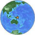
7.1 - NEW BRITAIN REGION, PAPUA NEW GUINEA
| Magnitude | 7.1 |
| Date-Time |
|
| Location | 5.217S 151.774E |
| Depth | 53 km |
| Distances |
|
| Location Uncertainty | Horizontal: 6.7 km; Vertical 5.8 km |
| Parameters | Nph = 116; Dmin = 121.7 km; Rmss = 1.36 seconds; Gp = 24° Version = |
| Event ID | us 20002am6 |
For updates, maps, and technical information, see:
Event Page or USGS
Earthquake Hazards Program
Disclaimer