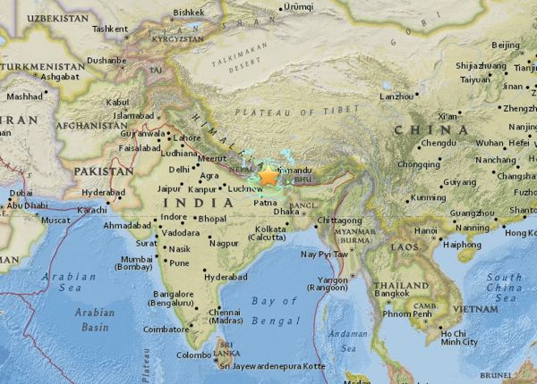
Map of May 12, 2015 earthquake epicenter via USGS
The U.S. Geological Society (USGS) is reporting a 7.3-magnitude earthquake in Nepal this morning (May 12, 2015). It comes on the heels of a powerful 7.9-magnitude quake that struck less than 50 miles from Nepal’s capital city of Kathmandu on April 25. Today’s earthquake is also less than 50 miles from Kathmandu. It had its epicenter near the town of Namche Bazaar, near Mount Everest. According to the Nepali government – at this writing (May 12 at 7:30 a.m. CDT, or 1230 UTC), least 29 people have been killed and 1,006 injured. More than 8,000 people were killed and 18,000 injured – and many historic buildings destroyed – in the first quake two weeks ago.
At least six aftershocks of magnitude 5 or higher have struck since the main quake. There have been hundreds of aftershocks in this region since the April 25 quake. The quake struck at a depth of 9.3 miles (15 km), according to the USGS. This is the same depth as the April 25 quake.
Follow the latest developments on the BBC’s live page
May 5 article from The Guardian has links to places to donate to Nepal’s earthquake victims
The USGS reports details of the quake as follows:
Time
2015-05-12 07:05:19 (UTC)
Nearby Cities
18km (11mi) SE of Kodari, Nepal
59km (37mi) ENE of Banepa, Nepal
62km (39mi) ENE of Panaoti, Nepal
76km (47mi) ENE of Kathmandu, Nepal
77km (48mi) ENE of Patan, Nepal
#NepalEarthquake2 Casualties being moved from village #Mrigu to #Kathmandu by #IAF's MI-17 V5 helicopter. pic.twitter.com/kmdxzY4QVg
— Sitanshu Kar (@SpokespersonMoD) May 12, 2015
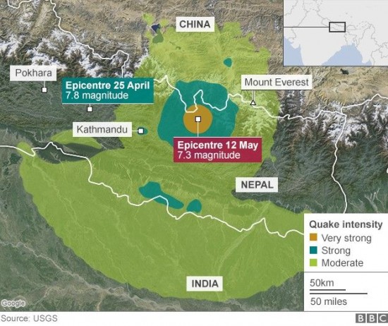
The map below, from the BBC, shows the location of the quake’s epicenter.
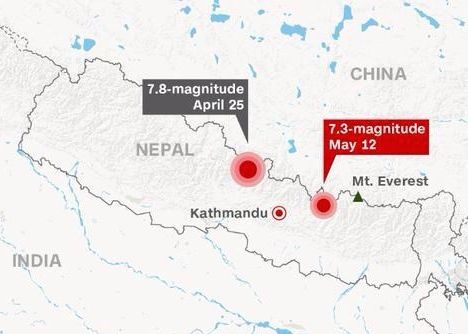
Map via @meschultz1010 on Twitter.
Why do such powerful earthquakes occur in this region? Nepal sits on a part of Earth where one of our planet’s great land plates – called the India plate by scientists – is pushing beneath another (the Eurasia plate to the north). At the location of this earthquake, the India plate is converging with Eurasia at a rate of 45 mm/year towards the north-northeast, driving an uplift of the Himalayan mountain range. For example, Mount Everest – highest mountain on Earth – is still growing taller at a fraction of an inch (3-5mm) per year. USGS said:
The preliminary location, size and focal mechanism of the April 25 earthquake are consistent with its occurrence on the main subduction thrust interface between the India and Eurasia plates.
USGS also said that – although located at a major plate boundary with a history of large-to-great sized earthquakes – large earthquakes in this region are rare in the documented historical era.
Just four events of M6 or larger have occurred within 250 km of the April 25, 2015 earthquake over the past century. One, a M 6.9 earthquake in August 1988, 240 km to the southeast of the April 25 event, caused close to 1500 fatalities. The largest, an M 8.0 event known as the 1934 Nepal-Bihar earthquake, occurred in a similar location to the 1988 event. It severely damaged Kathmandu, and is thought to have caused around 10,600 fatalities.
Read more: The science behind Nepal earthquakes
© 2014 Earthsky Communications Inc
http://earthsky.org/earth/another-7-magnitude-earthquake-in-nepal