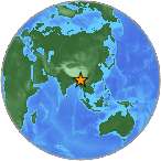
M6.9 - BURMA
| Magnitude | 6.9 |
| Date-Time |
|
| Location | 23.133N 94.900E |
| Depth | 134 km |
| Distances |
|
| Location Uncertainty | Horizontal: 7.0 km; Vertical 6.1 km |
| Parameters | Nph = 130; Dmin = 409.7 km; Rmss = 1.17 seconds; Gp = 23° Version = |
| Event ID | us 20005hqz |
For updates, maps, and technical information, see:
Event Page or USGS
Earthquake Hazards Program
Disclaimer