Data from NASA satellites is being used to help scientists
analyze how El Niño – a natural, regularly-occurring event that sees
large volumes of warm water move through the Pacific Ocean – is
affecting a population of tiny ocean plants. A decline in the number
of these plants can cause big disruptions to coastal fishing
industries.
During El Niño years, large volumes of warm water – roughly equivilent to half the volume of the Mediterranean Sea – move across the Pacific, altering everything from storm systems in the atmosphere to the tiniest plants residing below the ocean waves.
That warm water has a particular effect on tiny organisms, stopping cold waters from rising and cutting off nutrients carried by the currents. The disruption of that process, known as upwelling, essentially starves a population of small plants called phytoplankton, which form the base of the food chain. When phytoplankton numbers drop, it can have a knock-on effect on coastal fishing industries, with the fish themselves finding themselves without a key food source.
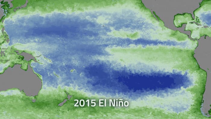
Now, researchers have been using satellite data, gathered by instruments such as the Moderate Resolution Imaging Spectrometer on NASA's Aqua probe, to look at the color of the ocean. That information is then processed by ocean color software called SeaDAS to map exactly where phytoplankton are more or less abundant. The color of the water allows scientists to determine how much green chlorophyll is present, which directly translates to the amount of phytoplankton in that area.
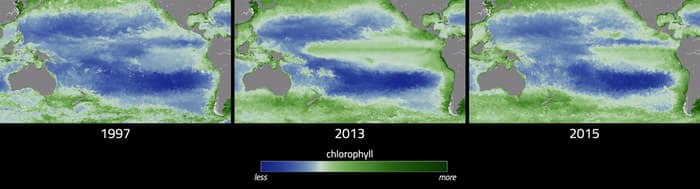
Generated from months of satellite data, the color maps provide a visualiation of El Niño's impact on phytoplankton, showing a drop in populations at the height of the current event in December 2015. As El Niño subsides, the researchers are continuing to watch the populations, studying when and where the phytoplankton reappear.
The team has also worked to compared the current event to the 1997-98 occurrence, finding that the drop in chlorophyll, and therefore the effect on coastal phytoplankton population, was much less severe this time around. This is attributed to the events being centered in different geographical locations, with the warm water influx affecting coastal areas more during the older event.
The use of satellite data isn't the only ongoing effort to better understand El Niño events. One other NASA team is looking to use supercomputers to analyze the ebbs and flows of nutrients, which in turn could allow managers of fisheries to estimate how much fish will be caught in any given year.
Looking forward, the researchers hope to make more complex assertions, using satellite data to describe, based on the flow of nutrients, where individual species of phytoplankton will bloom or recede, providing even more in-depth information as to the health of the wider ocean ecosystem.
Source: NASA