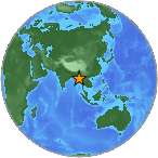
6.8 - BURMA
| Magnitude | 6.8 |
| Date-Time |
|
| Location | 20.919N 94.579E |
| Depth | 84 km |
| Distances |
|
| Location Uncertainty | Horizontal: 5.2 km; Vertical 3.7 km |
| Parameters | Nph = 117; Dmin = 199.8 km; Rmss = 1.35 seconds; Gp = 24° Version = |
| Event ID | us 10006gbf |
For updates, maps, and technical information, see:
Event Page or USGS
Earthquake Hazards Program
National Earthquake Information Center
U.S. Geological Survey
http://earthquake.usgs.gov/regional/neic/